Chapter 2 Core and Settlement Strategy – the extractive industry should be considered
crucial to unlocking the county’s potential
It is noted in the Draft CDP that the county is...
Chapter 2 Core and Settlement Strategy
Closed12 Jan, 2021, 9:00am - 23 Mar, 2021, 5:00pm
CHAPTER 2: CORE AND SETTLEMENT STRATEGY
AIM: Provide For The Growth Of County Laois In Line With The National Planning Framework / Regional Spatial And Economic Strategy (RSES) To Accommodate A Target Population Of Up To 94,700 By 2027 In The Settlements And Rural Areas Of County Laois.
2.1 INTRODUCTION
Planning Authorities are required to prepare and incorporate a Core Strategy that shows the Development Plan is consistent with national and regional objectives under the National Planning Framework (NPF) and the relevant Regional Spatial and Economic Strategy (RSES).
Under the Act, a Core Strategy focuses on:
- Defining a settlement hierarchy for the County that is consistent with the NPF and RSES.
- Transposing the prescribed NPF and RSES housing and population targets set at County level for the rural and urban centres identified within the settlement hierarchy.
- Providing an evidence-based rationale for the land proposed to be zoned for residential and mixed-use development having regard to the capacity of existing zoned land and the phasing of development taking account of the location of public transport and services.
- Demonstrating how the Planning Authority has had regard to the statutory Retail Planning Guidelines in setting out objectives for retail development.
The Core Strategy sets out a vision for Laois and strategic aims required to deliver this vision. The development of this Core Strategy has been guided by the Department of Environment Heritage and Local Government ‘Guidance Note on Core Strategies’ (2010), taking into account relevant changes brought about through the publication of the NPF and RSES. The Core Strategy of this Development Plan provides relevant information to demonstrate consistency with both the NPF and RSES and sets out core aims that, in turn, define and shape the following:
- preferred growth locations,
- revised population targets and population distribution and
- land use zoning requirements .
These are expressed in the Core Strategy Table 2.15 and related zoning maps in Volume 2, Settlement Plans.
2.2 Strategic Aims
The strategic aims which relate to the advancement of this plan are set out hereunder. These aims are addressed fully in subsequent chapters within the plan. A series of specific Core Strategy policy objectives are included in Section 2.8.
- To guide the future development of Laois in line with national and regional objectives set out in the NPF and RSES and other national guidelines and policies;
- To promote and facilitate the development of the County in accordance with the provisions of the Core Strategy, including directing development in line with the settlement hierarchy and promoting development at an appropriate scale that is reflective of the terms of the Core Strategy Table and zoning maps.
- To apply the Settlement Hierarchy to determine the scale, rate and location of proposed developments and apply appropriate development management measures to ensure compliance with the Settlement Hierarchy including the population targets for the County.
- To promote the delivery of at least 30% of all new homes that are targeted in settlements within their existing built-up footprints;
- To ensure that development is promoted, supported or facilitated through the Laois County Development Plan that provides for climate action including the increased risk of flooding and the promotion of sustainable transport options and renewable energy where possible in order to achieve a successful transition to a low carbon economy;
- To support the achievement of more self-sustaining towns and villages through residential and employment opportunities together with supporting social and community facilities
- To monitor and maintain a record of residential development permitted in settlements designated under the Settlement Hierarchy in order to ensure compliance with the population allocations defined by the Core Strategy and to adjust the approach to permitting development proposals in instances where Core Strategy objectives are not being met.
Underpinning the strategic aims above in relation to population growth, housing requirements and the future spatial development of our county are the following complimentary strategic aims which are integral in delivering the vision for the county during the period 2021-2027:
- To Build on the regional-level linkages between County Laois and other parts of the Eastern and Midlands Region and adjoining regions such as the South Region and Mid-West Region by supporting the implementation of regional spatial and economic strategies, collaborating on support for critical enabling infrastructure, such as inter-regional road and rail linkages, and co-operating on areas of mutual planning interest;
- To Target Foreign Direct Investment (FDI) and Irish Indigenous industries to appropriate zoned locations in the Key Towns of Portlaoise and Graiguecullen / Carlow and the Self Sustaining Growth Town of Portarlington and build on the economic strengths and tourism opportunities of County Laois in a balanced and sustainable manner focusing on the opportunities as outlined in the following sections;
- To Facilitate the provision of and improvements to community, social and recreational infrastructure and ensure universal access to all to such facilities throughout the county for all its residents;
- To Facilitate Job creation within the County to ensure that the county grows in a sustainable manner;
- To provide for sustainable transport infrastructure and connectivity including walking and cycling infrastructure and initiatives and optimise the return of investment on infrastructure while preserving the natural and built heritage;
- To achieve a sustainable, integrated and low carbon transport system for the county and to protect, improve and extend water services and other enabling infrastructure in line with national, regional and local population and economic growth for the count;
- To Protect, conserve and enhance the built, natural and cultural environment through promoting awareness, utilising relevant heritage legislation and promoting good quality urban and rural design;
- To Support the development of key infrastructure such as telecommunications, electricity, gas to enable economic development.
2.3 Strategic Development of County Laois Within a National Context (NPF)
The National Planning Framework (NPF) is a high-level strategy that will shape growth and development in Ireland out to the year 2040. The NPF draws upon lessons learned from the National Spatial Strategy 2002-2022 and provides a framework for the sustainable development of Ireland’s existing settlements.
As a framework document it sets in train a process by which more detailed planning documents must follow, including the relevant RSES and County Development Plan. It sets out ten National Strategic Outcomes (NSO’s) which underpin the overarching vision for the country and serve as shared goals and contains a range of National Policy Objectives providing a wider context for targeting future growth across the country.
With regards the Eastern and Midland Region, the NPF states that the region’s most significant place-making challenge will be to plan and deliver future development in a way that enhances and reinforces its urban and rural structure and moves more towards self-sustaining, rather than commuter driven activity.
In turn, this allows its various city, metropolitan, town, village and rural components to play to their strengths, while above all, moving away from a sprawl-led development model. The NPF identifies an urban structure for the Region based on commuting patterns, with reference to the EU/OECD definition of ‘functional urban areas’ (FUAs) which is used to identify areas with different sub-regional interdependencies and influence in the region.
Furthermore, the NPF includes specific targets related to securing compact and sustainable growth in Ireland’s towns and cities, recognising that the physical format of urban development in Ireland is one of our greatest national development challenges. As such it states that within the Eastern and Midlands Region, 30% of all housing outside of Dublin City and its suburb footprints are to be delivered within existing urban footprints.
The NPF further states that projecting housing requirements more accurately into the future at a Regional Spatial and Economic Strategy and local authority development plan level (e.g. through Core Strategies) will be enabled by the provision of new statutory guidelines to ensure consistency of approach, implementation and monitoring. This is enshrined in National Policy Objective 36 (NPF; p95);
National Policy Objective 36: New statutory guidelines, supported by wider methodologies and data sources, will be put in place under Section 28 of the Planning and Development Act to improve the evidence base, effectiveness and consistency of the planning process for housing provision at regional, metropolitan and local authority levels. This will be supported by the provision of standardised requirements by regulation for the recording of planning and housing data by the local authorities in order to provide a consistent and robust evidence base for housing policy formulation.
2.3.1 IMPLEMENTATION ROADMAP FOR THE NATIONAL PLANNING FRAMEWORK
The Implementation Roadmap for the National Planning Framework (July 2018) highlights the Governments focus on achieving alignment between national, regional and local planning policy and practice. It addresses issues around the legal status of the NPF and provides transitional population projections for the period up to 2031. It also sets out mechanisms to ensure that Development Plans will broadly align with the NPF and RSES’s to address the six-year period up to 2026/2027.
The Roadmap provides transitional population projections for these milestones at a regional and county scale, in order to inform Development Plans for the period 2026 and 2031. The transitional population projections for the Eastern and Midland Region are listed in the table below.
Table 2.1: Transitional Regional and County Population Projections to 2031 for the Eastern and Midland Regional Assembly.
|
Regions and Counties |
2016 |
2026 |
2031 |
|
MIDLANDS |
|||
|
Westmeath |
89,000 |
96,500-98,500 |
100,000-102,500 |
|
Laois |
84,500 |
92,500-94,000 |
95,500-97,500 |
|
Offaly |
78,000 |
85,000-86,500 |
88,000-90,000 |
|
Longford |
41,000 |
44,500-45,500 |
46,000-47,000 |
|
Subtotal |
292,500 |
318,500-324,500 |
329,500-337,000 |
Source: Extract from NPF Implementation Roadmap, p13
2.3.2 HOUSING NEEDS DEMAND ASSESSMENT
In order to ensure that the plan-making system is supported by a robust methodology to inform policies and funding initiatives around housing and associated land requirements, the NPF (NPO 37) states that a Housing Need Demand Assessment (HNDA) will be developed by each Local Authority to support the preparation of housing strategies and all related housing policy outputs, e.g. City and County development plans, local area plans, traveller accommodation plans etc.
The purpose of the HNDA tool is to:
- Assist local authorities to develop long-term strategic views of housing need across all tenures.
- Provide a robust evidence base to support decisions about new housing supply, wider investment and housing related services that inform an overall national housing profile.
- Inform policies about the proportion of social and affordable housing required, including the need for different types and sizes of provision.
- Provide evidence to inform policies related to the provision of specialist housing and housing related services.
The Core Strategy must give effect to the NPF and RSES hierarchy by setting population targets and associated requirements for housing. This must now be undertaken through the HDNA process.This Core Strategy Chapter sets out the population targets and housing requirements for Laois for the period 2021-2027. The HNDA process is elaborated and presented in greater detail in the Draft Housing Strategy (see Appendix 3).
2.4 Strategic Development of County Laois within a Regional Context (Eastern & Midlands Region)
The Regional Spatial and Economic Strategy (RSES) for the Eastern and Midland region came into force in June 2019, superseding the Regional Planning Guidelines for the Midland Region. The RSES is a high-level plan that seeks to support the implementation of the NPF by providing a strategic planning and economic framework for the region’s sustainable growth and development. It echoes the NPF in emphasising sustainable development patterns and seeks to focus growth within the footprint of existing urban areas and in key regional growth settlements.
The RSES seeks to determine at a regional scale how best to achieve the shared goals set out in the National Strategic Outcomes (NSOs) of the NPF. To this end, the Strategy sets out 16 Regional Strategic Outcomes (RSOs), which are aligned with international, EU and national policy and which in turn set the framework for City and County development plans.
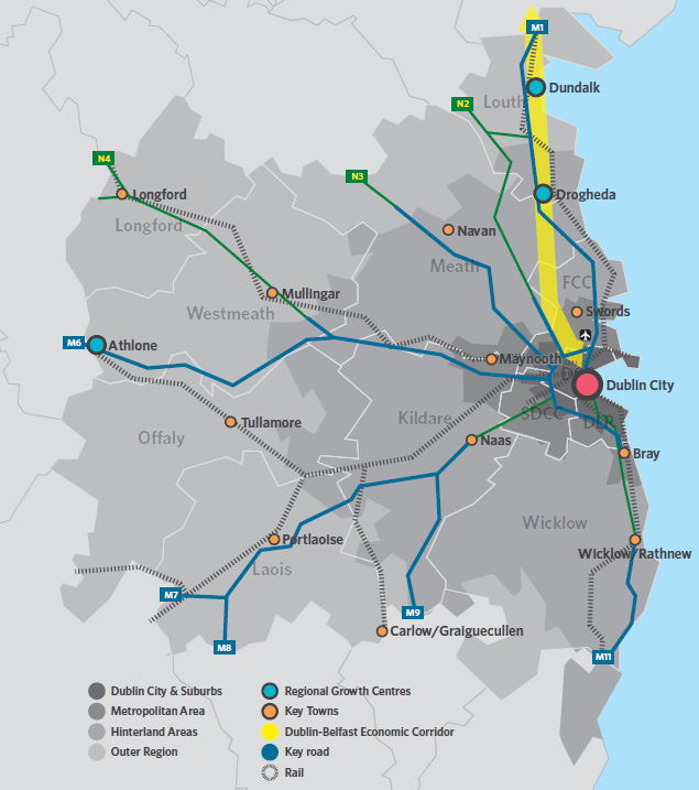
The RSES also sets out a settlement hierarchy for the Region and identifies key growth areas which will see significant development up to 2031 and beyond. There are three distinct areas across the Eastern and Midland Region comprising of the Dublin Metropolitan Area, the Core Region and the Gateway Region (of which Laois is located).
Figure 2.1: Settlement Strategy for the Eastern and Midlands Region (Fig 4.2, RSES)
2.4.1 SETTLEMENT HIERARCHY FOR THE REGION
Within the growth strategy for the region, the RSES has also determined a settlement hierarchy, depicted in Figure 2.1 and settlement hierarchy table below.
Table 2.2: Settlement Hierarchy for the Region
|
Dublin City and Suburbs |
International business core with a highly concentrated and diversified employment base and higher order of retail, arts, culture and leisure offer. Acts as a national transport hub with strong inter and intra-regional connections and an extensive commuter catchment |
|
Regional Growth Centres |
Regional Growth Centres are large towns with a high level of self-sustaining employment and services that act as regional economic drivers and play a significant role for a wide catchment area. |
|
Key Towns |
Large economically active service and/or county towns that provide employment for their surrounding areas and with high-quality transport links and the capacity to act as growth drivers to complement the Regional Growth Centres |
|
Self-Sustaining Growth Towns |
Self-Sustaining Growth Towns with a moderate level of jobs and services – includes sub-county market towns and commuter towns with good transport links and capacity for continued commensurate growth to more self-sustaining. |
|
Self-Sustaining Towns |
Self-Sustaining Towns with high levels of population growth and a weak employment base which are reliant on other areas for employment and/or services and which require targeted catch up’ investment to become more self-sustaining |
|
Towns and villages |
Towns and villages with local service and employment functions |
|
Rural |
Villages and the wider rural region |
Within the top three tiers of the hierarchy, settlements are clearly defined by the RSES. Settlements within the other four tiers are to be further defined in each County’s Development Plans. The Regional Growth Centres consist of Athlone, Drogheda and Dundalk which will be supported by Key Towns.
Co Laois is located in the Midland Region Strategy Planning Area of the Eastern and Midland Regional Assembly. To achieve effective regional development, Dublin and the regional growth centre of Athlone will be supported by the complementary development and regeneration of a small number of selected key towns such as Portlaoise and Graiguecullen/Carlow.
The RSES 2019, indicates the functional areas comprising of the Dublin Metropolitan Area, Core Region and the Gateway Region. Co Laois is part located within the Core region and the Gateway region. The Core region includes the peri-urban hinterlands in the commuter catchment around Dublin, whilst the gateway region acts as an inter regional gateway to the rest of the island.
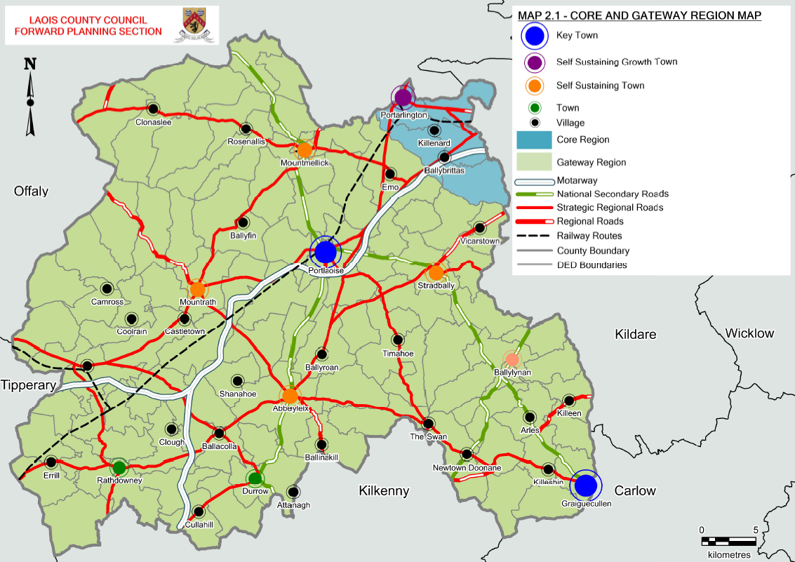
Map 2.1: Core and Gateway Region within Laois
|
Region |
Growth Enablers |
|
Core Region |
To promote continued growth at a more sustainable rate , whilst providing for increased employment and improved local economies , services and functions to allow towns become more self sustaining and to create the quality of life to attract investment. Catch up investment to promote consolidation and improvement in the sustainability of those areas that have experienced significant population growth but have a weak level of services and employment for residents. Portarlington is located within the regional functional area. |
|
Gateway Region |
Portlaoise Key Town plays a regional role in providing key employment and services for their own extensive hinterland Graiguecullen Key Town also has an important function as a town that straddles the regional boundary with the southern region and acts as a Gateway in this respect. It too, will play a regional role in providing key employment and services for its own extensive hinterland. Regeneration of small towns and villages, with a focus on the identification of the rural town and village and rural regeneration priorities to bring vibrancy to these areas. |
In relation to Co Laois, the Settlement Strategy for the region designates Portlaoise and Graiguecullen aS Key Towns, recognising that the towns provide a function at a much higher level than its resident population and provides key employment and services for its extensive hinterlands. Within the higher order settlements of Portlaoise and Graiguecullen[1], the RSES asserts that core strategies should apply higher densities in these towns. However, the RSES further states there should be a graded reduction in residential densities for Self-Sustaining Growth Towns, Self-Sustaining Towns, towns and villages that are commensurate to the existing built environment.
In developing this settlement hierarchy, the RSES recognises that population and employment size are not the sole determinant of a settlement’s functional role or in the consideration of its strategic regional significance. The strategy states that;
‘Some towns with a large population base located within the catchment of Dublin have emerged mainly as commuting towns, with a level of function significantly lower than their population base. Conversely, other towns have a level of function higher than their population base and play a key regional role’ (EMRA RSES, P46).
A number of key criteria were considered in the development of the asset base, which can be summarised as follows from Table 3.1 of the RSES. This approach has been utilised to guide the development of Laois’s Settlement Hierarchy, as elaborated in Section 2.6.
Table 2.3: Asset Based Approach to choosing the settlement hierarchy for Co Laois
|
DATA INDICATOR |
DESCRIPTION |
RATIONALE |
|
SCALE |
The scale of population, growth rates and local ambition for sustainable compact growth
|
Settlements of Critical mass of population to drive county and add to regional development The growth rates were applied to identify the capacity for future growth. Balancing high growth rates with investment in job creation, social and physical infrastructure has guided the settlement hierarchy for Co Laois. The NPF designations of Portlaoise and Graiguecullen as Key towns within the Region, both of which have the critical mass and ability to drive regional growth for the Midlands and the Southern region in combination with Carlow. Portlaoise is identified as a KEY town with a population of 22,050 and has a jobs to resident worker ratio of 0.997 Griaguecullen is identified as a KEY town with a population of 4,692 (together with Carlow Town, the population is 24,272which is also a Key town within the Southern Region Assembly areas RSES) Carlow/Graiguecullen has a jobs to resident worker ratio of 0.881. |
|
FUNCTION |
The scale of employment provision and commuting flows; Particular sub-regional interdependencies and influence
|
The mapping of the Functional Urban Area for Laois has determined the commuter catchment of spread of the influence of the settlement . AIRO has provided this information to Laois County Council which indicates the FUA for Portlaoise, Tullamore, Carlow and Kildare. This information has informed the settlement hierarchy. The Commuter data for Laois shows us which towns within the settlement hierarchy are commuter based and which are self sustaining. Co Laois is particularly fortunate to have a high level of rail infrastructure which has made commuting from the county a strong feature a sustainable manner. The settlement strategy has justified the settlement status of each town based on their assets and in line with the settlement typologies in the RSES. The Retail Hierarchy for Co Laois has taken into account the RSES designations, Retail Planning Guidelines and a review of the Retail Strategy 2017-2023 has been carried out. The designated settlements within the County Settlement Strategy already provide a good mix of convenience and comparison shopping and this is reflected in the plans for each of the towns in the County. |
|
PLACEMAKING |
This is linked to ‘Functionality’ in terms of provision of suitable sites and property solutions to meet enterprise and labour force expectations |
Quality of life factors are important in how well a place functions and in attracting people to live, invest, work and visit in. Access to a range of amenities such as cultural, social , health , education, etc are integral to the successful development of any town or village. A review of all assets in this regard for each town and village was carried out to inform their placement on the hierarchy. In relation to Portlaoise – the Key Town – Midland Hosital Portlaoise provides an important health care function for the town and its hinterland stretching beyond the county boundary. Additional to this primary health care centres provide important services and are located in Portarlington at Kilnacourt House and Mountmellick. The pobal HP Deprivation Index which measures the affluence and disadvantage in the County has been mapped to ascertain the current position and where potential areas for investment exist. In relation to improving places within the county, leveraging Urban Regeneration Development Funding (URDF) has proved successful for Portlaoise in terms of transitioning to a low carbon town and also celebrating its heritage and reimaging a Cultural Quarter within Portlaoise Town Centre. Rural Regeneration Development Funding (RRDF) is also applicable to the towns of the county with populations less than 10,000 people. Other streams of funding utilized to improve places within the County are Town and Village Renewal Scheme (TVRS) and funding from Laois Partnership through the Local Community Development Committee. |
|
ENTERPRISE ECOSYSTEM |
The availability of economic development assets and clusters
|
The location of strategic employment opportunities is guided by the location of existing economic opportunities upon which to develop. To this end, in Portlaoise J17 National Enterprise Park (Togher) is a substantial land bank for future job creation, given its location on the M7/M8. Other opportunities exist in Portarlington adjoining the Railway station – the former Avon Lands. Other Strategic employment zones have been identified in locations across the settlement strategy appropriate to the scale and function of the town and services required. |
|
CONNECTIVITY |
Transport accessibility and trip profiles, including internal trips
|
County Laois is serviced by 3 rail stations at Portarlington, Portlaoise and Ballybrophy which connects the county with both north south routes and east west in Portarlington. In particular the Key Town of Portlaoise is progressing public bus and rail improvements to service the town and Graiguecullen in relation to connecting in with the bus and rail in Carlow Town. Walking and cycling are key objectives for each of the towns within the settlement strategy.
|
|
NATURAL CAPITAL |
Environmental sensitivities, resources and assets, Water quality, flood risk
|
The natural capital within the county such as Designated sites Non designated sites Green infrastructure Ground water extraction Peatlands and forested areas The baseline information for the County used in the context of developing the SEA / AA/ SFRA has informed the development of the settlement hierarchy and the growth of each town and village. Strategic Flood Risk Assessment has interrogated zoning maps to ensure measures are put in place to protect such zones. The potential of areas to respond to climate change actions in terms of energy and waste has also been considered and informs the strategy. |
|
INFRASTRUCTURE |
Current and planned infrastructure capacity
|
Water services and Irish water data in relation to capacities and future potential and investment have been used to inform the growth of settlements. Many of the towns have routes for roads objectives for future development and specifically local transport plans will further inform the capacity of the towns and villages and look at integrating all forms of transport in a sustainable manner. |
2.4.2 SETTLEMENT HIERARCHY FOR LAOIS
In developing a settlement hierarchy for County Laois, an Asset Based Approach similar to that used in the preparation of the RSES was adopted (as indicated in Section 2.3). This amended version identifies and builds on a combination of social, economic and natural assets and potential that is available within towns and smaller settlements in the County. This has also been informed by the criteria listed in the Hierarchy of Settlements and related Infrastructure considered by NPF.
Table 2.4: Settlement Hierarchy for Laois
|
SETTLEMENT TYPOLOGY |
DESCRIPTION |
SETTLEMENTS |
POPULATION 2016 |
|
KEY TOWNS |
Large economically active service and/or county towns that provide employment for their surrounding areas and with high-quality transport links and the capacity to act as growth drivers to complement the Regional Growth Centres. |
Portlaoise |
22050 |
|
Graiguecullen |
4692 |
||
|
SELF-SUSTAINING GROWTH TOWNS |
Self-Sustaining Growth Towns with a moderate level of jobs and services – includes sub-county market towns and commuter towns with good transport links and capacity for continued commensurate growth to become more self- sustaining |
Portarlington |
6,596 (8,368 total including Offaly side) |
|
SELF-SUSTAINING TOWNS |
Self-Sustaining Towns with high levels of population growth and a weak employment base which are reliant on other areas for employment and/or services and which require targeted ‘catch up’ investment to become more self-sustaining. |
Mountmellick |
4777 |
|
Abbeyleix |
1770 |
||
|
Stradbally |
1350 |
||
|
Mountrath |
1774 |
||
|
TOWNS AND VILLAGES |
Towns and villages with local service and employment functions |
Durrow |
835 |
|
Rathdowney |
1271 |
||
|
Ballylinan |
1101 |
||
|
VILLAGES (Pop > 500) |
Villages that serve their local area |
Clonaslee |
566 |
|
Killenard |
671 |
||
|
Ballyroan |
563 |
||
|
Borris In Ossary |
508 |
||
|
RURAL REMAINDER (including villages with population <500) |
36173 |
||
2.5 Laois Core Strategy Map
The Core Strategy Map (Map 2.2) provides a visual representation of the settlement distribution throughout the county and identifies the settlement hierarchy in the context of transport and infrastructure available, including the county’s national primary and secondary routes along with regional and local roads and the county’s railway line.
Map 2.2: Core Strategy Map
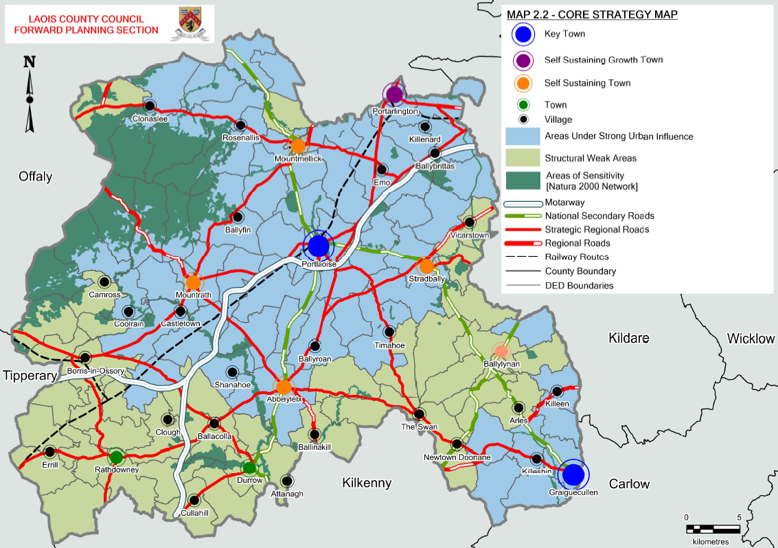
2.5.1 RURAL TYPOLOGIES
As required by the Core Strategy Guidance 2010, the Core Strategy must contain the classification of differing rural area types in map format in accordance with the 2005 Planning Guidelines on sustainable rural housing, which has been included in the Core Strategy Map. This classification is also an important factor in facilitating the development rural one off dwellings in the countryside in accordance with National Policy Objective 19 of the RSES – [Ensure, in providing for the development of rural housing, that a distinction is made between areas under strong urban influence, ie, within the commuter catchment of cities and large towns and centres of employment, and elsewhere], which is discussed in Chapter 4 on rural housing policy and indicated in Map 2.2 Core Strategy Map.
Rural area typologies where established by analysing data for each Electoral Division against a range of criteria including, commuting patterns, planning applications for rural housing over the past 3 years, environmental sensitivity, population change and pobal deprivation indices. In County Laois the following rural housing area designations apply:
Areas under Strong Urban Influence
Those rural areas within easy commuting distance of the main urban centres in County Laois and adjacent counties including the GDA[2] which are experiencing pressure from the development of urban generated housing in the open countryside. These areas are essentially:-
- The north and eastern areas in the County
- National, Strategic Regional Routes and Regional Routes as defined in Chapter 10
Continued high levels of single rural houses in these locations would inhibit the growth of the County’s urban areas which would result in a failure to achieve the growth targets. It would also cause further deterioration of rural amenities.
The key development plan objectives in these areas seeks to facilitate the genuine housing requirements of the rural community as identified by the planning authority in the light of local conditions while on the other hand directing urban generated development to areas zoned for new housing development in towns and villages.
Structurally Weak Areas
The rural areas generally exhibit characteristics such as persistent and significant population decline as well as a weaker economic structure based on indices of income, employment and economic growth. These rural areas are more distant from the major urban areas and the associated pressure from urban generated housing.
2.6 Population Projections to Meet Regional Population Target
According to the 2016 Census the total population of Laois is 84,697, an increase of 5.1% or 4,138 persons in the five year period since the 2011 Census – this was the 5th highest rate of growth in the state. The highest rates of growth in the state were recorded in Fingal (8.8%) and Meath (5.9%). The level of growth in Laois was significantly above the state average of 3.8% and slightly below the Eastern and Midland Regional Authority (EMRA) of 5.4%. A detailed analysis of population growth can be found in Section 3.1 of the Housing Strategy in Appendix 3.
Table 2.5: NPF / RSES Population Targets to 2026 and 2031
|
|
Census 2016 |
2026 NPF / RSES Target |
2031 NPF / RSES Target |
|
EMRA Region |
2,329,000 |
2,566,500-2,619,000 |
2,668,000-2,740,500 |
|
Midlands |
292, 500 |
318,500-324,500 |
329,500-337,000 |
|
Laois |
84,647 |
92,000-94,500 |
95,500-97,500 |
Source: Implementation Roadmap for NPF: Appendix 2
2.6.1 APPROACH
The approach to realize the population target as set out in the NPF implementation roadmap for County Laois, in its key towns and other settlements and rural area is set out in a robust evidence based analysis on requirements, completions / delivery and the social and physical capacity of the County’s settlements. This was done by analyzing the capacity of the all the towns and villages throughout the county to ascertain where future growth could be supported and informed by the following:
- NPF and RSES guidance;
- Existing population and other demographics relating to the county;
- Planning history and levels of activity on sites / completions of development;
- Availability of infrastructure within each settlement;
- SEA / AA/ SFRA recommendations;
- Environmental constraints;
- Regeneration opportunities within settlements through identification of areas of dereliction/ vacancy, etc;
- Potential for economic and social development
- Proposals for climate action in national, regional and local contexts.
2.6.2 POPULATION TRENDS
Within Laois, the County saw a population increase of 5.1% (+4,138 persons) during this period, as the population increased to 84,697 from 80,559. The level of growth in Laois was significantly above the state average of 3.8% and slightly below the Eastern and Midland Regional Authority (EMRA) of 5.4%. The County has had a steady growth of population since 1991. And even though the growth rates increased considerably over the 1996-2006 and 2006-2011, it dropped from 20.1% in 2011 to 5.1% in 2016 resulting in a slight growth of the population.
Table 2.6 Population Growth in County Laois 1996 - 2016
|
Year |
1996 |
2002 |
2006 |
2011 |
2016 |
|
Population |
52,945 |
58,774 |
67,059 |
80,559 |
84,697 |
|
Actual Change |
- |
5,829 |
8,285 |
13,500 |
4,138 |
|
% Change |
- |
11.0 |
14.1 |
20.1 |
5.1 |
|
Average Annual Increase |
- |
971 |
2,071 |
2,700 |
827 |
Source: CSO Statbank
According to the CSO’s parameters, a total of 40,979 people (48.3%) were living in urban settlements in Laois in 2016. 43,718 (51.6%) were living in smaller towns and villages, as well as in the rural remainder of the County. In 2011, census results showed a distribution between the urban and rural population as 47.3% and 52.6% respectively. Thus, Laois is slightly becoming more urban in nature as a whole.
The change in the population between successive Census can be broken down into the combined effect of natural increase (births less deaths) and net migration (immigration less emigration). The table below presents the components of intercensal population change back to 2002, which indicates the overall trend of the components align with the State. While the birth and death rates defining the natural growth of the population are close to the State figures over this period, the migration variation is above the Irish national average and is pushing the rate of population change in the County above the national figure. Within the County, except for the period of 2006-2011 where drastic fluctuations occurred, the overall trend of the components of population change shows a decline since 2002, which indicates that population is increasing with a slower growth rate.
Table 2.7: Components of Population Change
|
COMPONENT |
2002 |
2006 |
2011 |
2016 |
|
Change in Pop since previous Census |
5829 |
8285 |
13500 |
4138 |
|
Births since previous Census |
4630 |
3835 |
6701 |
6123 |
|
Natural Increase since previous Census |
1900 |
2300 |
4703 |
3888 |
|
Net Migration since previous Census |
3929 |
5985 |
8797 |
250 |
|
Birth rate since previous Census (Avg. Annual Rate per 1000) |
13.8 |
15.2 |
18.2 |
14.8 |
|
Death Rate since previous Census (Avg. Annual Rate per 1000) |
8.1 |
6.1 |
5.4 |
5.4 |
|
Rate of Natural Increase since previous Census (Avg. Annual Rate per 1000) |
5.7 |
32.9 |
12.7 |
9.4 |
|
Rate of Change in Population since previous Census (Avg. Annual Rate per 1000) |
17.4 |
9.1 |
36.6 |
10 |
|
Rate of Net Migration since previous Census (Avg. Annual Rate per 1000) |
11.7 |
23.8 |
23.8 |
0.6 |
Source CSO Statbank
2.6.3 POPULATION PROJECTIONS
A number of population scenarios for County Laois have been investigated to 2031, including two “Non-intervention Scenarios” relying upon growth rate of the population over the previous 5-year intercensal period. These non-intervention scenarios utilise a projection of population developed using the Cohort Component Method (CCM). They are called ‘Non-Intervention’ as they do not assume a policy-based interaction on the modeled trajectory of population growth across Laois as required by the NPF and RSES. CCM is used internationally as the best-in-class methodology for demographic projection, including by the Central Statistics Office (CSO) to produce the Irish National and Regional population and labour force projections. It closely examines the interactions between the three key components driving changes in the population: mortality, fertility and migration.
Details of these scenarios are summarised in Section 3.1.5 of the Draft Housing Strategy in Appendix 3.
Policy-Intervention Scenario
The total projected population growth for County Laois for the period 2016-2027 is 10,003, from 84,697 to 94,700. The population projections of this Plan are based on a policy intervention scenario where the NPF/RSES population targets are used as the fixed variables and then an interpolation of the required level of change per annum was developed for the County from baseline year 2016 to NPF/RSES target years 2026 and 2031; thus, producing annualised figures over the period of 2021 and 2027 which is the lifetime of the Development Plan. Projections in this scenario indicates that the population of County Laois would increase to 89,349 by 2021 and to 94,700 by 2027, an increase of 6280.
Table 2.8: Projected Population Growth Over the Plan Period based upon NPF/RSES 2021 and 2031 Targets
|
Year |
Total Population in County Laois |
Annual Population Increase during Year |
Annual Population Increase 2021-2027 |
Total Population Increase 2021-2027 |
Total Population Increase 2016-2027 |
|
2006 |
67,059 |
14.10% |
- |
- |
- |
|
2011 |
80,559 |
20.10% |
- |
- |
- |
|
2016 |
84,697 |
5.10% |
- |
- |
- |
|
2017 |
85,627 |
1.10% |
930 |
- |
- |
|
2018 |
86,558 |
1.10% |
930 |
- |
- |
|
2019 |
87,488 |
1.10% |
930 |
- |
- |
|
2020 |
88,418 |
1.10% |
930 |
- |
- |
|
2021 |
89,349 |
1.10% |
930 |
- |
- |
|
2022 |
90,279 |
1.10% |
930 |
- |
- |
|
2023 |
91,209 |
1.10% |
930 |
- |
- |
|
2024 |
92,139 |
1.10% |
930 |
- |
- |
|
2025 |
93,070 |
1.10% |
930 |
- |
- |
|
2026 |
94,000 |
1.10% |
930 |
- |
- |
|
2027 |
94,700 |
0.74% |
700 |
6,280 |
10,000 |
|
2028 |
95,400 |
0.74% |
700 |
- |
- |
|
2029 |
96,100 |
0.74% |
700 |
- |
- |
|
2030 |
96,800 |
0.74% |
700 |
- |
- |
|
2031 |
97,500 |
0.74% |
700 |
- |
- |
A further breakdown of population targets by settlement is indicated in the Core Strategy Table in Section 2.8.1.
2.7 HOUSING REQUIREMENT
This section sets out key considerations in relation to residential land requirements for this Plan period as set out in the NPF and RSES. The NPF notes that the concept of headroom based solely on zoned land provision does not account for housing yield arising from the re-use of existing housing stock, mixed-use development, urban intensification or infill or brownfield development. Indeed, projected population growth must be planned in accordance with NPF National Policy Objectives 3a, b and c, which target infill and brownfield development within the existing built footprint of urban settlements, in particular the objective to target at least 30% of all new homes in settlements other than the five Cities and their suburbs, within their existing built-up footprints.
|
WHAT IS THE BUILT UP FOOTPRINT The built-up footprint of an urban settlement is defined by the CSO as an area with a minimum of 50 occupied dwellings, with a maximum distance between any dwelling and the building closest to it of 100 metres, and where there is evidence of an urban centre (shop, school etc.). The built-up area of each settlement has been defined by the Census 2016 and is indicated on each settlement zoning map in Volume 2 of this Plan. |
A key objective of the Plan is to integrate and reconcile predicted requirements for residential land with actual provision on the ground having regard to, among other factors, the spatial distribution of development lands throughout the county and the need to support sustainable settlement patterns which in the longer term can be provided with essential physical and social infrastructure.
The NPF sets out a new, standardised methodology that addresses the differentiation between zoned land that is available for development and zoned land that requires significant further investment in services for infrastructure for development to be realised. In this regard, lands have only been identified for development where they are able to connect to existing development services, i.e. road and footpath access including public lighting, foul sewer drainage, surface water drainage and water supply, for which there is service capacity available, and can therefore accommodate new development.
These lands are also positioned within the existing built-up footprint of established settlements or contiguous to existing developed lands. Regard has also been given to the availability of serviced lands as well as the identification of lands that are not currently sufficiently serviced to support new development but have potential to become fully serviced within the life of the plan.
2.7.1 HOUSING TARGETS AND HOUSEHOLD SIZE
This section sets out key considerations in relation to residential land requirements for this Plan period as set out in the NPF and RSES. The NPF notes that the concept of headroom based solely on zoned land provision does not account for housing yield arising from the re-use of existing housing stock, mixed-use development, urban intensification or infill or brownfield development. Indeed, projected population growth must be planned in accordance with NPF National Policy Objectives 3a, b and c, which target infill and brownfield development within the existing built footprint of urban settlements, in particular the objective to target at least 30% of all new homes in settlements other than the five Cities and their suburbs, within their existing built-up footprints.
Table 2.9: Projected Households over the Plan Period
|
Year |
Total Population in Laois |
Avg Household Size in Laois |
No of Households (private) |
No of Anticpated Houses per annum |
Total Anticipated Houses 2021 – 2027 |
Avg Anticipated Houses per Annum 2021 – 2027 |
|
2006 |
67059 |
2.97 |
22591 |
|
|
|
|
2011 |
80559 |
2.88 |
28020 |
|
|
|
|
2016 |
84697 |
2.91 |
29107 |
|
|
|
|
2017 |
85627 |
2.89 |
29630 |
523 |
|
|
|
2018 |
86558 |
2.87 |
30161 |
531 |
|
|
|
2019 |
87488 |
2.85 |
30693 |
537 |
|
|
|
2020 |
88418 |
2.83 |
31240 |
543 |
|
|
|
2021 |
89349 |
2.81 |
31789 |
549 |
|
|
|
2022 |
90279 |
2.79 |
32344 |
555 |
|
|
|
2023 |
91209 |
2.77 |
32905 |
561 |
|
|
|
2024 |
92139 |
2.75 |
33472 |
567 |
|
|
|
2025 |
93070 |
2.73 |
34046 |
574 |
|
|
|
2026 |
94000 |
2.71 |
34625 |
580 |
|
|
|
2027 |
94700 |
2.70 |
35126 |
501 |
3886 |
555 |
The above total anticipated housing figure has been based on a graduated household size/occupancy. The average occupancy rate in Laois in 2016 was 2.9 compared to a state average of 2.75. However, the NPF states that this is expected to decline to around 2.5 by 2040, while also acknowledging that household sizes in urban areas tend to be smaller than in the suburbs or rural parts of the country.
In line with this projected trend, a graduated average household size is utilised within this Plan, however this rate is expected to fall to 2.7 by 2027 based on an evidenced-based assessment of Laois household size over 2006 - 2016 indicated in the Table below.
Table 2.10: Projected Household Size
|
Year |
Total Population in County Laois |
Average Household Size in County Laois |
|
2006 |
67059 |
2.97 |
|
2011 |
80559 |
2.88 |
|
2016 |
84697 |
2.91 |
|
2017 |
85627 |
2.89 |
|
2018 |
86558 |
2.87 |
|
2019 |
87488 |
2.85 |
|
2020 |
88418 |
2.83 |
|
2021 |
89349 |
2.81 |
|
2022 |
90279 |
2.79 |
|
2023 |
91209 |
2.77 |
|
2024 |
92139 |
2.75 |
|
2025 |
93070 |
2.73 |
|
2026 |
94000 |
2.71 |
|
2027 |
94700 |
2.70 |
2.7.2 HOUSING PERMITTED AND COMPLETED
The global recession and collapse of the property market in 2008 resulted in the stagnation of household construction in the County and across the State. Census data indicates that the private housing stock of the County in 2011 was 28,020[3] and increased marginally by 3.7% to 29,107[4] in 2016. Since then, there has been a sustained rise in the number of residential units completed. The table below indicates that the housing stock has increased by 817[5]units or 2.7% during the period 2016 - 2020.
Table 2.11: Unit Completion 2016 – 2020
|
Year |
2016 |
2017 |
2018 |
2019 |
2020 (Jan – Sep) |
|
Unit Completion |
103 |
117 |
235 |
242 |
120 |
Source: CSO Statbank
2.7.3 RESIDENTIAL LAND ZONED IN PREVIOUS THE PLAN
The following table sets out the area of land zoned for residential use / mixture of residential and other uses in the County Development Plan 2017-2023 and Draft County Development Plan 2021 - 2027, together with the number of housing units allocated to these lands.
Table 2.12: Residential Zoned Land
|
|
CDP 2017 - 2023 |
CDP 2021 - 2027 |
|
Land zoned to accommodate residential development |
273 ha |
149 ha |
|
No of residential units[6] |
3,216 units |
5,202 |
2.8 Core Strategy and Housing Allocation
The Section of the Plan indicates the distribution of future population and housing across the county’s settlements. The position of each town in the settlement hierarchy has been clearly linked to the quantitative population allocations. The distribution of future population and household growth in this Plan is based on the key principles of the NPF and RSES of delivering more compact growth but must also align population and employment growth. Growth is therefore targeted in large urban centres that have the capacity and greatest potential for growth on a sustainable platform. In addition there will be greater co-ordination between land use zoning and infrastructure availability through the implementation of the ‘Tiered Approach to Land Use Zoning’ set out in the NPF as indicated in Section 2.7. Along with key demographic change in indicated in Section 2.6.2, the following key considerations also informed this approach:
1. Compact Growth
In accordance with the principles of compact Growth, at least 30% of housing within settlements is to be within the existing built up footprint area in conjunction with sequential development of settlements. The preferred choice for residential development is within town and village centres, however there are limiting factors which may be applicable e.g. the historic formation of many of the main towns in County Laois, flooding implications (as identified in the Strategic Flood Risk Assessment (SFRA), inadequate access, limited and fragmented land holdings and the requirement to facilitate retail development in these locations in accordance with the sequential test under the Retail Planning: Guidelines for Planning Authorities (DECLG, 2012).
This Plan also recognises the social and economic benefits of the redevelopment of brownfield lands to promote urban regeneration and will continue to support the delivery of compact growth and regeneration of under utilised sites in towns and villages throughout Laois. The achievement of this, the NPF notes, has the potential to make a transformational difference. It can bring new life and footfall to existing settlements, contribute to the viability of services, shops and public transport, increase housing supply and enable more people to be closer to employment and recreational opportunities, as well as supporting a more sustainable transport mode shift.
An analysis of the potential capacity of infill and brownfield lands zoned for residential, town/village centre, or mixed use developments in all settlements indicates that approximately 1,709 units could be delivered on these lands. This equates to 33% of the household allocation for the County. The development of these lands will make an important contribution to the creation of more sustainable communities in the County and will support the implementation of the national and regional policy objectives of creating more compact settlements.
2. Climate Change and Environmental Sensitivity
Climate change has an increasing role to play in how we plan for the future. This Plan has a critical role to play in ensuring our communities develop having regard to sustainable infrastructure networks which build resilience to climate change. A key component is delivering housing in a compact, sustainable way which better integrates with sustainable transport modes to become less dependent on single vehicular use.
Consideration is given to; ground and surface water vulnerability and any potential environmental impact (including SEA, HAD, EU Water Framework Directive, River Basin Management Plans and Flood Risk Management) requirements; availability of services and infrastructure; potential for economic and social development of the settlement; the sequential test; ground and surface water vulnerability; planning history and market availability/choice. A Strategic Environmental Assessment and Appropriate Assessment has been prepared in tandem with the Core Strategy. The Core Strategy has had regard to both assessments with any changes/recommendations incorporated into the strategy.
3. Extant Planning Permission
A detailed review of extant planning permissions has been carried out and a total of 1562 units has been recorded. It has been concluded that there are a number of unknowns in relation to the delivery of these units. While the Council works closely with associated parties to assist in bringing forward these sites for development, external market forces may prohibit this. It is considered that there is a relatively small number of these permissions to wither over the plan period. Many of those that have acquired extension of durations on permissions during the plan period 2017-2023 pursuant to Section 42 of the Planning and Development Act 2000 (as amended), may also not come forward during this Plan period.
The Core Strategy Table (Table 2.15) does not deduct population that would be catered for in committed land by way of extant permission or Part VIII approvals.
4. Vacant Housing Stock
Census 2016 results record a total housing stock of 33,115 in Laois, an increase of just 541 on 2011 levels. In that time, the rate of vacant housing has fallen from 12.5% to 10.0% (-785 units). In other words, there were 35.5 vacant homes per 1,000 people in 2016, a fall from the corresponding figure of 48.88 recorded in 2011. This indicates the existing vacant stock is absorbing much of the growing need for housing in the county.
Table 2.16: Residential Vacancy
|
Housing Stock |
Vacant Holiday Homes |
Other Vacant Dwellings |
Total Vacancy |
% Vacancy |
|
33,115 |
139 |
3,163 |
3,302 |
10 |
Source: CSO Statbank
2.8.1 CORE STRATEGY TABLE
The ‘Core Strategy Table’ below, sets out the population projections and household allocation for each settlement up to 2027. This table provides details of the most recent population (2016), population projections, the housing allocation for 2021 - 2027 for each settlement based on the Draft Housing Strategy (Appendix 3) analysis, the number of housing units which must be delivered within the built up footprint of each settlement and the quantum of land required for the delivery of the housing allocation based on a specific density[7] for each settlement.
Following the population allocations set out in the Core Strategy Table below, zoning maps are provided in Volume 2, Settlement Plans, to reflect these figures and to indicate the quantum and locations of future development for the plan period.
It is considered that the lands identified for residential development are sufficient to meet the population targets set out in the Core Strategy Table and reflect each settlements role in the Settlement Hierarchy.
The amount and location of zoned lands required in each settlement was determined using an evidence-based settlement typology and asset-based approach, as detailed in Section 2.4.1 of the Plan and the considerations of Section 2.7.3.
The following table, Table 2.15 Core Strategy, indicates the population and housing projections for County Laois.
Table 2.15: Core Strategy Table
|
Settlement |
Population 2016 |
Population Allocation |
NPF Projected Population 2027
|
Projected Population increase to 2016 - 2027 |
Housing Allocation 2016-2027[8] |
Approx Units Completed 2016-2020[9] |
Housing Allocation for County Laois 2021-2027[10] |
Residential Units to be Delivered on Infill / Brownfield Sites[11] |
Residential Units to be Delivered on Greenfield Sites |
Quantum of Greenfield Land Required for Residential Development |
|
COUNTY LAOIS |
84,697 |
100% |
94,700 |
10,003 |
6,019 |
817 |
5,202 |
1,709
|
3,493 |
106.2 |
|
KEY TOWN (Density 35 units/ha) |
||||||||||
|
Portlaoise |
22,050 |
29.5% |
25,001
|
2,951 |
1,776 |
250 |
1,526 |
834 |
692 |
19.7
|
|
Graiguecullen |
4,692 |
9% |
5,592 |
900 |
542 |
50 |
492 |
0 |
492 |
14 |
|
SELF SUSTAINING GROWTH TOWN (30 units/ha) |
||||||||||
|
Portarlington |
6,596 |
14.5% |
8,046 |
1,450 |
873 |
25 |
848 |
310 |
538 |
17.9 |
|
SELF SUSTAINING TOWN (30 units/ha) |
||||||||||
|
Mountmellick |
4,777 |
3% |
5,077 |
300 |
181 |
0 |
181 |
60 |
121 |
4 |
|
Abbeyleix |
1,770 |
4% |
2,170 |
400 |
241 |
0 |
241 |
60 |
181 |
6 |
|
Stradbally |
1,350 |
3% |
1,650 |
300 |
181 |
16 |
165 |
130 |
35 |
1.1 |
|
Mountrath |
1,774 |
2.5% |
2,024 |
250 |
150 |
0 |
150 |
30 |
120 |
4 |
|
TOWNS (15 units/ha) |
||||||||||
|
Durrow |
835 |
1% |
935 |
100 |
60 |
0 |
60 |
25 |
35 |
2.3 |
|
Rathdowney |
1,271 |
1% |
1,371 |
100 |
60 |
0 |
60 |
20 |
40 |
2.6 |
|
Ballylinan |
1,101 |
3% |
1,401 |
300 |
181 |
12 |
169 |
25 |
144 |
9.5 |
|
VILLAGES POP > 500 (15 units/ha) |
||||||||||
|
Clonaslee |
566 |
1% |
666 |
100 |
60 |
9 |
51 |
0 |
51 |
3.4 |
|
Borris in Ossory |
508 |
1.25% |
633 |
125 |
75 |
0 |
75 |
40 |
35 |
2.3 |
|
Ballyroan |
563 |
1% |
668 |
105 |
63 |
0 |
63 |
47 |
16 |
1 |
|
Killenard |
671 |
0% |
671 |
0 |
0 |
3 |
0 |
0 |
0 |
0 |
|
VILLAGES POP <500 AND OPEN COUNTRYSIDE (12 units/ha) |
||||||||||
|
As above |
36,173 |
26.25% |
38,794 |
2,621 |
1,578 |
452 |
1,122[4] |
128 |
993 |
17.8 |
[8]CSO Statbank Housing Completion in County Laois 2016 – 2020 (Aug)
[9]This number is based on the policy intervention scenario as indicated in the Laois Housing Strategy and Housing Needs Demand Assessment 2021 – 2027. It is assumed that between 2016 and 2027, 6,019 will be required to reach NPF population projection of 94,700 by 2027. This number is based on an assumption that approximately 2,134 number of units would be delivered between 2016 and 2020, however the CSO Statbank figure for completed units in County Laois between 2016 – (Aug) 2020 was 817. Therefore a total of 5,202 units will be required during the lifetime of the Plan and to meet NPF population projections.
[10]It is estimated that 33% of Laois’ housing need can be delivered on infill and brownfield land
[11]This figure includes an approximation of 100 rural one off dwellings per annum over the lifetime of the Plan. Refer to Section 6.2 of the Laois Draft Housing Strategy and Housing Needs Demand Assessment for analysis of rural one off dwellings
2.9 Core Strategy Policies and Objectives
Laois County Council shall ensure that the future spatial development of Laois is directed by means of a plan led approach, directing residential and employment generating development to locations in accordance with National and Regional Policy, and with environmental carrying capacity, which can support investment in public infrastructure and services and which is sensitive to the physical character of the built and natural environment. This approach is enshrined in a number of Core Strategy Policy Objectives, as below.
|
Overarching Core Strategy Policy Objectives |
|
|
CS 01 |
Ensure that the future spatial development of County Laois is in accordance with the National Planning Framework 2040 (NPF) including the population targets set out under the Implementation Roadmap, and the Regional, Spatial and the Economic Strategy (RSES) for the Eastern and Midland Region 2019-2031. |
|
CS 02 |
Implement all land use planning policy and objectives in a manner which takes account of and is consistent with the Core Strategy in order to accelerate a transition to a greener, low carbon and climate resilient county with a focus on reduced travel demand through the promotion of sustainable settlement patterns. |
|
CS 03 |
In the assessment of development proposals, to take account of transport corridors, environmental carrying capacity, availability and/or capacity to provide waste water and water supply services, potential to conflict with Water Framework Directive objectives, potential to impact on the integrity of European sites and Annexed Habitats and species, features of biodiversity value including ecological networks, impact on landscape and visual characteristics, education and other socioeconomic objectives |
|
CS 04 |
Promote the integration of land use and transportation policies and to prioritise provision for cycling and walking travel modes and the strengthening of public transport |
|
CS 05 |
Support the regeneration of underused town centre and brownfield/infill lands along with the delivery of existing zoned and serviced lands to facilitate population growth and achieve sustainable compact growth targets of 30% of all new housing to be built within the existing urban footprint of targeted settlements in the County |
|
CS 06 |
Promote measures to reduce vacancy and the underuse of existing building stock and support initiatives that promote the reuse, refurbishment and retrofitting of existing buildings within urban centres and targeted settlements in the County |
|
CS 07 |
Incorporate, in the content of the County Development Plan, measures in accordance with Section 10 (n) of the Planning and Development Acts 2000 (as amended) for the promotion of sustainable settlement and transportation strategies in urban and rural areas including the promotion of measures to — (i) reduce energy demand in response to the likelihood of increases in energy and other costs due to long-term decline in non-renewable resources, (ii) reduce anthropogenic greenhouse gas emissions, and (iii) address the necessity of adaptation to climate change; in particular, having regard to location, layout and design of new development |
|
CS 08 |
Review the Local Area Plans for Portlaoise and Mountmellick. During the transition period between adoption of this county development plan and the adoption of the Local Area Plans for Portlaoise and Mountmellick , the objectives (including zoning objectives) , policies and standards in this county development plan shall apply. |
|
CS 09 |
Prepare a cross boundary Joint Local Area Plan (LAP) For Carlow / Graiguecullen in conjunction withCarlow County Council having regard to its location within the combined functional area of both local authorities[12]. |
|
CS 10 |
Prepare a Joint Local Area Plans for Portarlington in conjunction with Offaly County Council. During the transition period between adoption of this county development plan and the adoption of the Local Area Plans for Portarlington, policies and standards in this county development plan shall apply. |
|
CS 11 |
Ensure that Laois County Development Plan is consistent with Section 28 Guidelines. |
2.10 Future Settlement Growth
2.10.1 KEY TOWNS
Portlaoise and Graiguecullen are designated as Key Towns in the RSES, which are defined as ‘Large economically active service and/or county towns that provide employment for their surrounding areas and with high- quality transport links and the capacity to act as growth drivers to complement the Regional Growth Centres’.
2.10.1.1 Portlaoise
In line with this objective, the following provides a rationale for directing significant growth towards Portlaoise:
1. Population Profile and Growth
County Laois has experienced significant population growth in the past decade, growing by 26.3% over the ten year period between 2006 and 2016. In the same ten year period, Portlaoise experienced a significant population growth rate of 45%. The proportion of the county’s population living within Portlaoise has grown steadily over this period, rising from 21% in 2006 to 26% in 2016.
Table 2.14: Population statistics for County Laois and Portlaoise between 2002 and 2016
|
|
Persons 2002 |
Persons 2006 |
Persons 2011 |
Persons 2016 |
% Change 06-16 |
|
County Laois |
58,774 |
67,059 |
80,559 |
84,697 |
26.3 |
|
Portlaoise |
12,127 |
14,613 |
20,145 |
22,050 |
45 |
The 2016 Census reported 8,958 Portlaoise residents commute to either work (8,381) or third-level study (577) on a daily basis. Excluding mobile workers, those who work from or at home and those whose place of work, school or college could not be coded, a total of 6,623 Portlaoise residents regularly commute either to work (92%) or to third-level study (8%). Of those who commute to work, 63% commute to a location within County Laois and 37% leave the County.
The majority of Portlaoise commuters drive, accounting for 67% of those who commute to work and 28% of those commuting to third-level study. The next most popular modes of travel for workers is walking (9%) , and for third level students walking (21%) and bus (21%) were the next most popular.
Primary and secondary level students most popular mode of travel was passengers by car (57%), with walking (22%) and bus (13%) the next most popular. A large proportion of Portlaoise commuters to work are highly educated with nearly 44% holding a third-level or higher qualification. This compares to 53% for the state. The highest proportion of 29% work in the Wholesale or Retail sector with Education, Human Health and social work activities the next highest at 19%.
2. Strategic Infrastructure/Investment
As outlined under Project Ireland 2040 some of the other strategic infrastructure/ investment identified for Portlaoise include:
Transport Regional and Local Roads:
- Portlaoise Southern Distributor Road will be progressed over the course of the National Development Plan – Completed in 2019.
Health:
- A Mental Health project for a 40 bed Residential Unit.
Courts Service:
- Provision of a new or refurbished Courthouse.
Prison Service:
- Modernisation or replacement of the historic E Block in Portlaoise Prison.
The RSES states that Key Towns should seek commensurate population and employment growth, on high quality public transport corridors coupled with investment in services, amenities and sustainable transport
3. Regeneration and Low Carbon Town
The “Portlaoise Public Realm Strategy “2040 And Beyond: A Vision For Portlaoise” sets out a vision for the future development of Portlaoise town centre. Improvements to the public realm through a program of infrastructural works will provide a safe, attractive, and comfortable place to live, work and visit. Infrastructural improvements will prioritise pedestrians through measures such as traffic calming, street maintenance and traffic management in the historic town centre.
The town has also been designated Ireland’s first low carbon town which is support by RPO 4.72 of the RSES. The aim of the Low Carbon Town is to reduce the impact of the car on the public realm and improving the mix of uses within the town centre. This will be achieved by removing large volumes of traffic from congested areas, utilising the South Circular Road and by reconfiguration of existing traffic flows throughout the town centre.
Building on the development of this ‘Park and Stride’ policy Laois County Council will also be encouraging an increase in the adoption of cycling by extending on-road and off-road cycle ways and the creation of the Triogue River Blueway as an environmental and amenity objective.
The Local Authority will also be upgrading the laneway’s of Portlaoise by improving the overall look, retrofitting existing street lights with energy saving LED’s and adding additional lighting to poorly lit areas. Further energy efficient amenities will include the addition of 30 eCar charge Points and an extension of the number of solar powered compactor bins to 50. The Council has also received significant funding to develop a multi-point incubation hub called ‘The Cube’ for the development of a Low Carbon Centre of Excellence, assisting in attracting and developing companies with a low Carbon focus.
4. Strategic Employment Zone
Additional to this, it is objective to capitalise on Portlaoise’s location on the motorway and rail networks and proximity to the Greater Dublin Area. The zoning and servicing of land at Togher as a National Enterprise Park for enterprise, employment and industrial uses, in the immediate vicinity of national strategic transport infrastructure, represents a unique opportunity to develop a cluster of complementary enterprises and more generally a larger, more robust and diverse economic basis for the town, county and region. J17 National Enterprise Park Masterplan sets out the guidance in this respect.
|
Portlaoise Policy Objectives |
|
|
CS 12 |
Support the continued growth and sustainable development of Portlaoise to act as a growth driver in the region and to fulfill its role as a Key Town as outlined in the Regional Spatial and Economic Strategy 2019. |
|
CS 13 |
Direct population into the Key Town to ensure that population growth is appropriate in scale with its identified role in the Regional and County Settlement Hierarchy. |
|
CS 14 |
Require sustainable , compact , sequential growth in Portlaoise by consolidating the built up footprint[13] with a focus on the redevelopment and regeneration of infill and brownfield sites. |
|
CS 15 |
Apply increased residential densities where appropriate having regard to Sustainable Residential Developments in Urban Areas (2009) AND Apply appropriate development management measures in ensuring growth is appropriate and in compliance with the RSES 2019. |
|
CS 16 |
Implement the actions of the ‘Portlaoise Public Realm Strategy “2040 And Beyond: A Vision For Portlaoise’ to improve the character of the town of Portlaoise. |
|
CS 17 |
Support and facilitate the transition of Portlaoise to a low carbon centre of excellence in accordance with RPO 4.72 of the RSES. |
2.10.1.2 Graiguecullen
Graiguecullen is designated as a Key Town in the RSES, which are defined as ‘Large economically active service and/or county towns that provide employment for their surrounding areas and with high- quality transport links and the capacity to act as growth drivers to complement the Regional Growth Centres’.
A joint LAP for the Carlow / Graiguecullen area was prepared in 2012 and further extended up to and including 22nd October 2022 after which time a new Joint Spatial Plan will be prepared for the Greater Carlow Graiguecullen Area in conjunction with Carlow County Council which will align with the policy provisions of the EMRA RSES and the Southern Regional Assembly RSES in order to comply with RPO 4.75.
In addition to this RPO 4.76 will be considered and inform the preparation of the Joint LAP - support the sustainable development of environmentally sensitive , low intensity amenity development associated with the Barrow Blueway subject to compliance with the Habitats directive and floods Directive.
The vision for the Greater Carlow Graiguecullen urban area is as follows:-
“A high-functioning, inclusive, compact and accessible greater urban area, underpinned by a robust and diverse local economy comprising retail, commercial, industrial, education and tourism uses; with characteristics including a strong sense of place, a vibrant and vital town centre, opportunities for education and cultural experiences for all, a network of linked open spaces, recreational uses and other social infrastructure elements to provide for a good quality of life and increased emphasis on sustainable forms of transport and patterns of development”
The RSES states that Key Towns should seek commensurate population and employment growth, on high quality public transport corridors coupled with investment in services, amenities and sustainable transport.
|
Graiguecullen Policy Objectives |
|
|
CS 18 |
Support the continued growth and sustainable development of Graiguecullen to act as a growth driver in the region and to fulfill its role as a Key Town. |
|
CS 19 |
Work with Carlow County Council to Identify strategic housing and employment development areas and infrastructure investment requirements to promote greater coordinationand sequential delivery of serviced lands for development. |
|
CS 20 |
Promote higher densities at appropriate locations, owing to position on public transport network where appropriate to do so having regard to Guidelines for Planning Authorities on Sustainable Residential Developments in Urban Areas (DEHLG, 2009) and ensure that any plan or project associated with the provision of new housing is subject to Appropriate Assessment Screening in compliance with the Habitats Directive, and subsequent assessment as required. |
|
CS 21 |
Require sustainable, compact , sequential growth in Graiguecullen by consolidating the built up footprint[14] with a focus on the redevelopment and regeneration of infill and brownfield sites. |
2.10.2 SELF SUSTAINING GROWTH TOWN
The RSES defines ‘Self Sustaining Growth Towns’ as ‘Towns With A Moderate Level Of Jobs And Services – Includes Sub-County Market Towns And Commuter Towns With Good Transport Links And Capacity For Continued Commensurate Growth To Become More Self-Sustaining’.
Laois County Council has identified Portarlington as a Self Sustaining Growth Town. The population of Portarlington in the 2016 Census is 6,576 persons (Laois County Council Area) and 1,772 persons (Offaly County Council Area). An established measure of the employment “health” of a settlement is a measure called the “Jobs Ratio”. This is the relationship between the number of people in the labour force and the number of jobs in any defined area. A healthy area is considered to be one where the jobs ratio is around 70%. While not all towns will be able to reach this level, it is considered reasonable that the plan should aim to increase the jobs ratio proportionately to accord with the town’s characteristics and level in the County settlement and employment hierarchy.
As indicated in Census 2016 Portarlington has a total labour force of 3,798 persons. The census also indicates that there are 1,349 jobs within the settlement of Portarlington. Given an indicated resident worker population of 3,103, Portarlington has a jobs to resident workers ratio of 0.435 which is below the definition of a healthy area where it is considered to be one where the jobs ratio is around 70%. However it should be noted that since 2016 a number of new enterprise / employment opportunities have been established namely – Portarlington Enterprise Centre is now at full capacity, sites within the Enterprise park have been further developed, investment in the Garden Shop, etc should be factored now into the figures going forward.
Portarlington is one of the most accessible towns within the Midlands Region by virtue of the Train station which has had substantial investment in recent years.
The National Planning Framework (NPF) includes a National Policy Objective to prepare a Joint Local Area Plan where a town and environs lie within the combined functional area of more than one Local Authority. The Joint LAP has set out an overall strategy for the proper planning and sustainable development of Portarlington in the context of the relevant county development plans for both counties
Due to the town’s proximity to the Greater Dublin Area and its location on the Dublin-Cork/ Dublin-Galway train line, Portarlington has experienced significant population growth since the beginning of the millennium. In this regard, the town’s population increased from 4,001 persons in 2002 to 8,368 persons in 2016. Portarlington is ranked third in overall population size in County Laois and fourth in County Offaly behind the county towns of Portlaoise and Tullamore.
While such population growth has created the critical mass to support the town’s own services and industry, this growth has in turn placed an even greater demand on the town’s infrastructure, in particular education, housing, recreational amenities and services.
The development of Portarlington over the lifetime of this plan shall be focused on employment generation, the consolidation of the town centre and the provision of community and social services and the transition to a low carbon town.
The Council is currently preparing a Portarlington Regeneration Strategy for the town centre. The aim of the strategy is to create a vision for Portarlington's public realm, including the suitable re-use of Market House and Square. The aim of the Strategy will be to identify key urban spaces designated for enhancement and connection, pedestrian priority linkages and proposals to better link the historic core with adjacent amenities (People's Park, River Barrow, Leisure Centre and play areas)
|
Overarching Core Strategy Policy Objectives |
|
|
CS 22 |
Promote consolidation in Self-Sustaining Growth Towns coupled with targeted investment where required to improve local employment, services and sustainable transport options and to become more self-sustaining settlements. |
|
CS 23 |
Prepare a Urban Regeneration Strategy for the Town of Portarlington to ensure a framework for its future development which would seek to identify opportunities for heritage led regeneration in the Market Square and pedestrian and cycle linkages between Portarlington Railway Station and (i) Market Square/Main Street (ii) Portarlington Leisure Centre (ii) ColaisteIosagain and Derryounce Lakes and Trails; |
|
CS 24 |
Promote higher densities at appropriate locations, owing to position on public transport network where appropriate to do so having regard to Guidelines for Planning Authorities on Sustainable Residential Developments in Urban Areas (DEHLG, 2009) and ensure that any plan or project associated with the provision of new housing is subject to Appropriate Assessment Screening in compliance with the Habitats Directive, and subsequent assessment as required; |
2.10.3 SELF SUSTAINING TOWNS
Self-Sustaining Towns, according to the RSES, are towns with high levels of population growth and a weak employment base which are reliant on other areas for employment and/or services and which require targeted ‘catch up’ investment to become more self-sustaining.
Mountmellick, Abbeyleix, Mountrath, Stradbally form this tier of the settlement hierarchy. Each of these towns have experienced limited growth over the past development plan period.
The Self Sustaining Towns are so designated, because they are important urban centres within their hinterlands, providing community and infrastructural facilities and services and the population base to maintain them. These towns perform important retail, residential, service and amenity functions for local, essentially rural hinterland and support the upper tiers of the urban hierarchy, including the key towns.
Many of these towns have experienced high levels of population growth over the last census period, in some cases without the necessary supporting services. The development of these towns needs to be increasingly aimed at consolidating growth within the Self sustaining Towns and better matching it to the development of social and physical infrastructure.
Mountmellick has a role to play in supporting both the Key towns of both Portlaoise and Tullamore within the Midlands Region.
Abbeyleix, Stradbally, Mountrath are also Self Sustaining Towns dispersed around the county on the national road network. These towns are considered appropriate for managed population growth over the plan period, together with employment opportunities, business, industry and tourism and infrastructural development.
The RSES states that population growth in Self-Sustaining towns shall be at a rate that seeks to achieve a balancing effect and shall be focused on consolidation and inclusion of policies in relation to improvements in services and employment provision
|
Self Sustaining Towns Policy Objectives |
|
|
CS 25 |
Promote commensurate population and employment growth in the designated Self- Sustaining towns, providing for natural increases and to become more economically self- sustaining, in line with the quality and capacity of public transport, services and infrastructure available. |
|
CS 26 |
Identify opportunities sites within the Self sustaining towns for residential , employment or social functions ; |
|
CS27 |
Ensure that population growth is appropriate in pace and scale and diversity of uses and services within its identified role in the settlement hierarchy. |
2.10.4 TOWNS
Durrow, Rathdowney andBallylinan are included within this tier of the settlement hierarchy. Facilitating housing is paramount to ensuring the sustainability, vitality and viability of the rural places of the Region, according to the RSES. Support for housing and population growth within rural towns and villages in County Laois will provide a viable alternative to rural one-off housing, contributing to the principle of compact growth.
These towns have an important role to play in performing local residential, retailing, social and leisure functions and providing appropriate local services to a wider rural hinterland. They have attractive streetscapes, physical settings and heritage buildings that present a strong visual character.
Rathdowney provides a range of services and facilities for the population of the immediately surrounding hinterland. It is a focus for social interaction in the west of the county, and provides linkages to the smaller settlement nodes [such as Errill and Donaghmore] in its district.
Durrow provides a limited range of services and facilities for the population of the immediately surrounding hinterland. It is a focus for social interaction in the south of the county, and provides linkages to the smaller settlement nodes in its districts.
Ballylinan also provides a limited range of services and facilities in the north eastern quadrant of the county for its population and that of its rural hinterland. Its proximity to Athy and Carlow has placed pressure on it from a commuting perspective and so it is considered appropriate to identify opportunities within the town that could grow employment and enterprise and potential serviced sites for residential purposes.
Having regard to their existing and envisaged size, their general structure as small country settlements, their range of housing requirements and their semi urban character, their plans include statutory zoning of particular land for particular purposes.
|
Towns Policy Objectives |
|
|
CS 28 |
Promote consolidation coupled with targeted rural housing and investment policies in Towns and Villages where required to improve local employment, services and sustainable transport options and to become more self-sustaining. |
|
CS 29 |
Promote regeneration opportunities within these towns to ensure their viability as service centres for the surrounding areas. |
2.10.5 VILLAGES AND RURAL AREAS
Laois has traditionally been a predominantly rural county. The 2016 Census results show a distribution between the urban and rural population as 48.4% and 51.6% respectively. In 2011, this distribution was as 47.4% and 52.6% respectively. Thus, the overall proportion of the County living in urban settlements is increasing.
Rural population will continue to be supported through the small towns and villages and through a sustainable approach to maintaining the rural population and rural economy, balanced against measures to protect the environment. Support for providing housing within our small towns and villages as an alternative to the consideration of one off housing in the countryside will be enable in this development plan in order to achieve the principles of compact growth while transitioning to a low carbon economy.
A national programme will be developed for new homes in small towns and villages with Local Authorities, public infrastructure agencies such as Irish Water and local communities providing serviced sites with appropriate infrastructure. Examples of this have already emerged in County Laois in Small towns such as Castletown and are planned in towns such as Killeen in the East of the County.
In making the choice to live either in a small town / village or open countryside, consideration must now be given to impact on the climate and what actions we need to take to be more sustainably responsible. Facilitating and encouraging people to live in more sustainable communities in towns and villages, near to essential services and public transport, is essential in addressing the climate change agenda and our transition to a low carbon society which is less dependent on private vehicle.
The structure of rural villages in Laois can be categorized as follows :
- Villages >500 population (depending on assets available / function within the county)
- Villages < 500 population
- Rural settlements
Villages such as Borris in Ossory, Ballyroan, Clonaslee and Killenard have an important role to play in performing local residential, retailing, social and leisure functions and providing appropriate local services to a wider rural hinterland. They have attractive streetscapes, physical settings and heritage buildings that present a strong visual character. These villages provide opportunities for future expansion/ provision of services such as community centres, local shop, pub, petrol outlet and have the potential to attract a population seeking to live in a rural environment.
Development growth should be low density, relative to the scale of the settlement, located as near as is practicable to the core area. Due to their existing and envisaged size, their general structure as small country settlements, their range of housing requirements and their semi urban character, their plans include statutory zoning of particular land for particular purposes.
Smaller Villages such as Ballinakill, Ballybrittas, Emo, Castletown, The Swan, etc have a limited service base and are to a large extent founded on the local primary school catchment area. These villages provide opportunities for future expansion/ provision of services such as community centres, local shop, pub, petrol outlet and have the potential to attract a population seeking to live in a rural environment.Development growth should be low density, relative to the scale of the settlement, located as near as is practicable to the core area.
Rural settlements are very small, sometimes embryonic rural settlements with a very small amount of development to date. These settlements are defined by their loose gathering of one-off houses and some public services dispersed within the settlement such as a church, school, shop, playing pitch and speed limits. Examples of these settlements include Arles,Attanagh, Ballyfin, Shanahoe, Ballaghmore, Kilbricken, Donaghmore, The Rock and Wolfhill. The availability of serviced sites, in tandem with schemes such as the Irish Water Scheme for Small Towns and Villages, will help to enable this.
|
Rural Areas Policy Objectives |
|
|
CS 30 |
Support housing at an appropriate scale and repopulation taking place within villages in a consolidated, sustainable and sequential manner, priority will be given to refurbishment of existing houses or appropriate replacement to current building standards within the existing footprint; |
|
CS 31 |
Promote the provision of serviced sites in line with investment opportunities by Irish Water in order to attract people to build their own homes and live in villages |
|
CS 32 |
Facilitate the expansion of villages and small towns to provide for employment, retail and social opportunities at an appropriate scale subject to normal planning requirements; |
|
CS 33 |
Support the servicing of rural villages (serviced sites) to provide an alternative to one-off housing in the countryside, in line with RSES Objective RPO 4.78. |
|
CS 34 |
Within the designated development limits of the rural villages in Volume 2, development will be permitted where it involves infilling, conversion, single site housing development, or the use of derelict or underused land or premises, subject to siting, design, protection of residential amenities and normal development management criteria. |
2.11 ENVIRONMENT AND ECOSYSTEMS SERVICES APPROACH
The development objectives in the Draft Development Plan are consistent, as far as practicable, with the conservation and protection of the environment. The accompanying Strategic Environmental Assessment (SEA), Appropriate Assessment (AA) and Strategic Flood Risk Assessment (SFRA) processes have informed the preparation of the Draft Plan (see Chapter 1: Introduction for a description of these processes and Volume 4 for associated documents detailing the findings). All recommendations made by these processes have been integrated into the Draft Plan and this will contribute towards environmental conservation and protection within the County and beyond.
Ecosystems are multifunctional communities of living organisms interacting with each other and their environment. Ecosystems provide a series of services for human well-being (ecosystem services) either directly or indirectly contributing towards human wellbeing. The Ecosystems Services Approach followed by the Plan provides a strategy for the integrated management of land, water and living resources that promotes conservation and sustainable use in an equitable way.
Ecosystem Services Approach principles include:
- Consideration of natural systems - by using knowledge of interactions in nature and how ecosystems function (this has been considered in preparing the Plan including at Chapter 11 “Biodiversity and Natural Heritage”)
- Taking into account of the services that ecosystems provide - including those that underpin social and economic well-being, such as flood and climate regulation (including at Plan Chapter 3 “Climate Action and Energy”),resources for food, fibre or fuel (including at Plan Chapters3 “Climate Action and Energy” and 9 “Rural Laois”), or recreation, culture and quality of life (including at Plan Chapter5 “Quality Of Life and Sustainable Communities”)
- Involving people - those who benefit from the ecosystem services and those managing them need to be involved in decisions that affect them. Public consultation has informed the preparation of the Draft Plan which will be further refined before adoption, taking into account submissions/observations made on the Draft Plan during public display.
Natural capital consists of renewable and non-renewable resources (e.g. plants, animals, air, water, soils, minerals) which need to be managed. In recognition of this, policy objectives have been integrated into the Plan that will contribute towards the management of air quality, noise pollution, light pollution, pollination, flood risk, water bodies and river basins and natural resources supporting energy production and recreation.
|
Ecosystems Approach Policy Objectives |
|
|
CS 35 |
Promote an Ecosystem Services Approach in the preparation of lower-level plans, strategies and Development Management |
|
CS 36 |
Contribute, as practicable, towards achievement of the 17 Sustainable Development Goals[15] of the United Nations’ 2030 Agenda for Sustainable Development, which came into force in 2016 |
[1] RPO 4.75 Requires Laois and Carlow County Councils to prepare a Joint Local Area Plan
[2]Greater Dublin Area
[3] CSO Statbank
[4] CSO Statbank
[5] CSO Statbank
[6] This figure did not account for rural one off dwellings
[7] This density is based on Section 28 Planning Guidelines - Sustainable Residential Development in Urban Areas (DEHLG, 2009)
[8]This number is based on the policy intervention scenario as indicated in the Laois Housing Strategy and Housing Needs Demand Assessment 2021 – 2027. It is assumed that between 2016 and 2027, 6,019 will be required to reach NPF population projection of 94,700 by 2027. This number is based on an assumption that approximately 2,134 number of units would be delivered between 2016 and 2020, however the CSO Statbank figure for completed units in County Laois between 2016 – (Aug) 2020 was 817. Therefore a total of 5,202 units will be required during the lifetime of the Plan and to meet NPF population projections.
[9]CSO Statbank Housing Completion in County Laois 2016 – 2020 (Aug)
[10]It is estimated that 33% of Laois’ housing need can be delivered on infill and brownfield land
[11]This figure includes an approximation of 100 rural one off dwellings per annum over the lifetime of the Plan. Refer to Section 6.2 of the Laois Draft Housing Strategy and Housing Needs Demand Assessment for analysis of rural one off dwellings
[12]The Joint LAP shall provide a coordinated planning framework to identify and deliver strategic sites and regeneration areasfor the future physical, economic and social development of Carlow/ Graiguecullen to ensure it achieves targeted compact growth of a minimum of 30% and ensure a coordinated approach is taken to the future growth and development of the of the combined urban area, ensuring that it has the capacity to grown sustainably and secure investment as a Key Town. The Joint LAP shall identify a boundary for the plan area and strategic housing and employment development areas and infrastructure investment requirements to promote greater coordination and sequential delivery of serviced lands for development. Regard shall be had to the respective housing, retail and other local authority strategies that may be in place.
[13] National Policy Objective 3C of the NPF 2018 states “deliver at least 30% of all new homes that are targeted in settlements other than the 5 cities and their suburbs , within their existing built up footprints”
[14] National Policy Objective 3C of the NPF 2018 states “deliver at least 30% of all new homes that are targeted in settlements other than the 5 cities and their suburbs , within their existing built up footprints”
[15] Including:
- Goal 1: End poverty in all its forms everywhere
- Goal 2: End hunger, achieve food security and improved nutrition and promote sustainable agriculture
- Goal 3: Ensure healthy lives and promote well-being for all at all ages
- Goal 4: Ensure inclusive and equitable quality education and promote lifelong learning opportunities for all
- Goal 5: Achieve gender equality and empower all women and girls
- Goal 6: Ensure availability and sustainable management of water and sanitation for all
- Goal 7: Ensure access to affordable, reliable, sustainable and modern energy for all
- Goal 8: Promote sustained, inclusive and sustainable economic growth, full and productive employment and decent work for all
- Goal 9: Build resilient infrastructure, promote inclusive and sustainable industrialization and foster innovation
- Goal 10: Reduce inequality within and among countries
- Goal 11: Make cities and human settlements inclusive, safe, resilient and sustainable
- Goal 12: Ensure sustainable consumption and production patterns
- Goal 13: Take urgent action to combat climate change and its impacts
- Goal 14: Conserve and sustainably use the oceans, seas and marine resources for sustainable development
- Goal 15: Protect, restore and promote sustainable use of terrestrial ecosystems, sustainably manage forests, combat desertification, and halt and reverse land degradation and halt biodiversity loss
- Goal 16: Promote peaceful and inclusive societies for sustainable development, provide access to justice for all and build effective, accountable and inclusive institutions at all levels
- Goal 17: Strengthen the means of implementation and revitalize the global partnership for sustainable development
[i] CSO Statbank Housing Completion in County Laois 2016 – 2020 (Aug)
Contents
Materials
Comments
Comments
Submission on Core and Settlement Strategy
The Assembly acknowledge the work that has gone into the preparation of Chapter 2 which details the Core Strategy and Settlement Strategy.
As part of Chapter 2, the Assembly welcome the...