See attached submission on the Heath pNHA
Chapter 11 Biodiversity and Natural Heritage
Closed12 Jan, 2021, 9:00am - 23 Mar, 2021, 5:00pm
CHAPTER 11: BIODIVERSITY AND NATURAL HERITAGE
Aim: To contribute towards the protection, conservation and management of biodiversity and natural heritage including sites designated at national and EU level and protected species and habitats outside of designated sites and to develop a green infrastructure network in the interests of the proper planning and sustainable development of the county.
11.1 INTRODUCTION
The County’s natural heritage and biodiversity is of local, national and international importance and is recognised as an important environmental and economic resource that requires care and management through the planning process. Laois has a wide range of habitat types and landscapes supporting diverse species both in natural and semi-natural state and managed locations. Natural heritage areas Includes the upland area of the Slieve Bloom Mountains, scenic river valleys of the Barrow and Nore, woodlands, rolling farmland and a network of mature biodiversity areas such as boglands, riparian habitats and hedgerows. Protecting and enhancing our biodiversity, ecosystems and landscapes is vital to the health, well-being and quality of life of our communities and assists societal adaption to the challenges of climate change.
11.2 POLICY CONTEXT
Ireland has signed and ratified a number of international conventions and agreements including the Convention on Biological Diversity, the Convention on the Conservation of European Wildlife and Natural Habitats (Bern) and the Convention on Wetlands of International Importance (Ramsar). These various obligations are given legal effect through both European and National legislation and have resulted in the designation of natural heritage sites throughout the country.
11.2.1 EU BIRDS AND HABITATS DIRECTIVES
EC Birds Directive (Directive 2009/147 EC) The EU Birds Directive (Council Directive 79/409/ EEC) and the EU Habitats Directive (European Directive 92/43/EEC) provides for the establishment of the Natura 2000 network of sites of highest biodiversity importance for rare and threatened habitats and species across the EU. The Natura 2000 network of European sites comprises Special Areas of Conservation (SAC), and Special Protection Areas (SPA).
11.2.2 NATIONAL LEGISLATION
Development Plans must include mandatory objectives for the conservation of the natural heritage and for the conservation of European sites and any other sites which may be prescribed. National legislation includes the following: Wildlife Acts 1976 and 2010 (as amended), the Planning and Development Act 2000 (as amended) and associated Regulations, European Union (Planning and Development), (Environmental Impact Assessment) Regulations 2018, the European Union (Water Policy) Regulations 2003 (as amended), the European Communities (Birds and Natural Habitats) Regulations 2011 (as amended), the European Communities (Environmental Liability) Regulations 2008 (as amended) and the Flora Protection Order 2015.
11.2.3 NATIONAL PLANNING FRAMEWORK (NPF)
The National Planning Framework (NPF) aims to protect and value our important and vulnerable habitats, landscapes, natural heritage and green spaces. It highlights the importance of the interrelationships between biodiversity, natural heritage, landscape and our green spaces. The NPF states that integrated planning for Green Infrastructure and ecosystem services will be incorporated into the preparation of statutory land use plans. It also refers to the importance of biodiversity and how the planning system will be responsive to our national environmental challenges and ensure that development occurs within environmental limits having regard to the requirements of all relevant environmental legislation.
11.2.4 REGIONAL SPATIAL AND ECONOMIC STRATEGY
The Strategy recognises the need to conserve and enhance the biodiversity of our protected habitats and species including landscape and heritage protection, to identify, protect and enhance our Green Infrastructure, to ensure the sustainable management of our natural resources, to build climate resilience, to support the transition to a low carbon economy by 2050 and the protection of the healthy natural environment to ensure clean air and water for all. In line with Regional Policy Objective (RPO) 3.4 of the Eastern and Midland Regional Spatial and Economic Strategy, the Council promotes an ecosystems services approach in the preparation of this County Development Plan.
11.2.5 NATIONAL BIODIVERSITY ACTION PLAN 2017 – 2021
The Plan sets out actions through which a range of government, civil and private sectors will undertake to achieve Ireland’s ‘Vision for Biodiversity’, and follows on from the work of the first and second National Biodiversity Action Plans. The objectives lay out a clear framework for Ireland’s national approach to biodiversity, ensuring that efforts and achievements of the past are built upon, while looking ahead to what can be achieved over the next five years and beyond.
11.2.6 LAOIS BIODIVERSITY ACTION PLAN
Laois County Council has developed a suite of Local Biodiversity Action Plans for Abbeyleix, Ballacolla, Cullahill, Emo, Killenard, Mountmellick and Portarlington with funding from Laois Partnership. Each Plan builds on the measures outlined in the National Biodiversity Action Plan.
11.2.7 ALL IRELAND POLLINATOR PLAN
One third of our bee species are threatened with extinction from Ireland. This is because we have drastically reduced the amount of food (flowers) and safe nesting sites in our landscapes. The All-Ireland Pollinator Plan is about all of us, from farmers to local authorities, to schools, gardeners and businesses, coming together to try to create an Ireland where pollinators can survive and thrive. The first Plan covers the period 2015-2020 and a new version will be developed to cover 2021-2025. Each sector have been targeted in the Plan including Councils where key actions have been identified to protect natural wildflower areas, promote pollinator friendly planting and raise awareness of the importance of biodiversity.
11.3 BIODIVERSITY AND CLIMATE CHANGE
At the national level, climate change has also become central to Ireland’s National Biodiversity Action Plan which focuses on removing threats and building resilience in Ireland’s ecosystems to help them adapt to climate change and other threats. Increasing our understanding of the effects of climate change on biodiversity and developing practical ways of mitigating such effects, are critical to limit the damage. Biodiversity can support efforts to reduce the negative effects of climate change. Conserved or restored habitats can remove carbon dioxide from the atmosphere, thus helping to address climate change by storing carbon in peatlands and other Green Infrastructure. Options to increase the adaptive capacity of biodiversity in the face of accelerating climate change include:
- Reducing non-climatic stresses, such as pollution, habitat loss and fragmentation and invasive alien species.
- Wider adoption of conservation and sustainable use practices including through the strengthening of protected area networks and Green Infrastructure.
11.4 DESIGNATED SITES
The National Parks and Wildlife Service of the Department of Environment, Heritage & Local Government is responsible for designating areas of special biodiversity interest in the context of national and European legislation. These areas include Special Areas of Conservation (SACs), Special Protection Areas (SPAs), Natural Heritage Areas (NHAs) and Statutory Nature Reserves. The county contains:
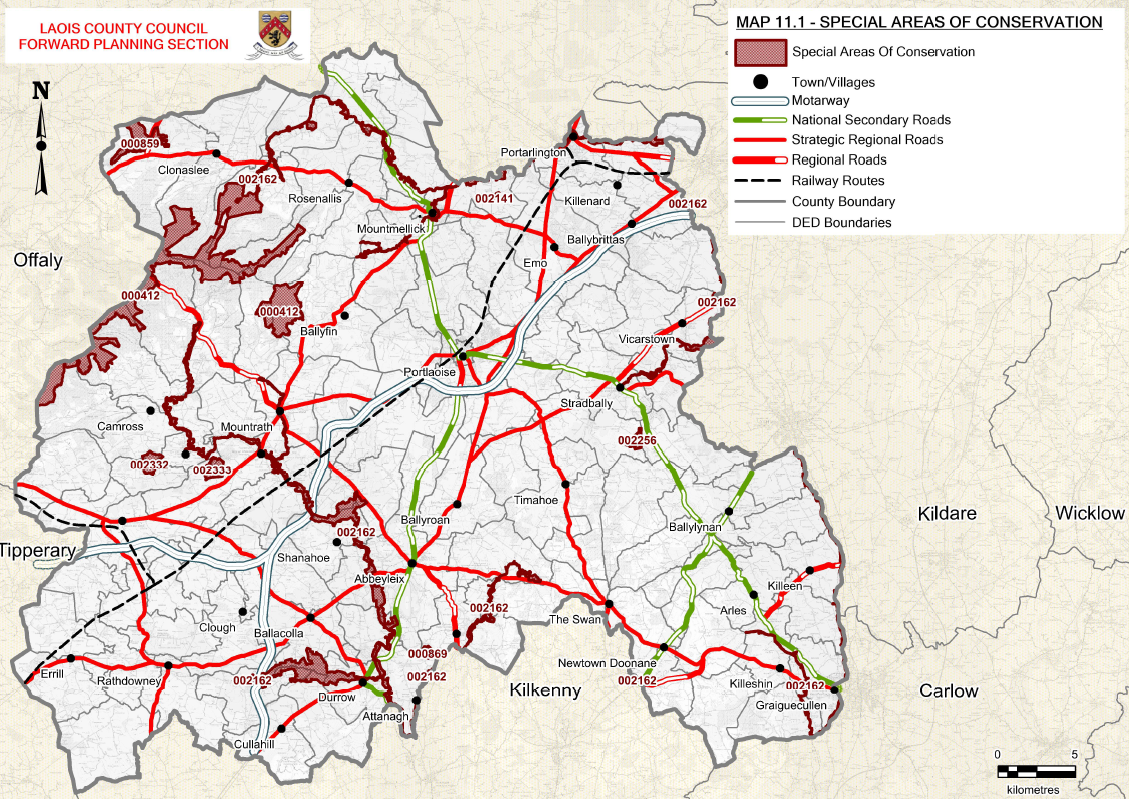
- 8 Special Areas of Conservation, SACs (See Map 11.1)
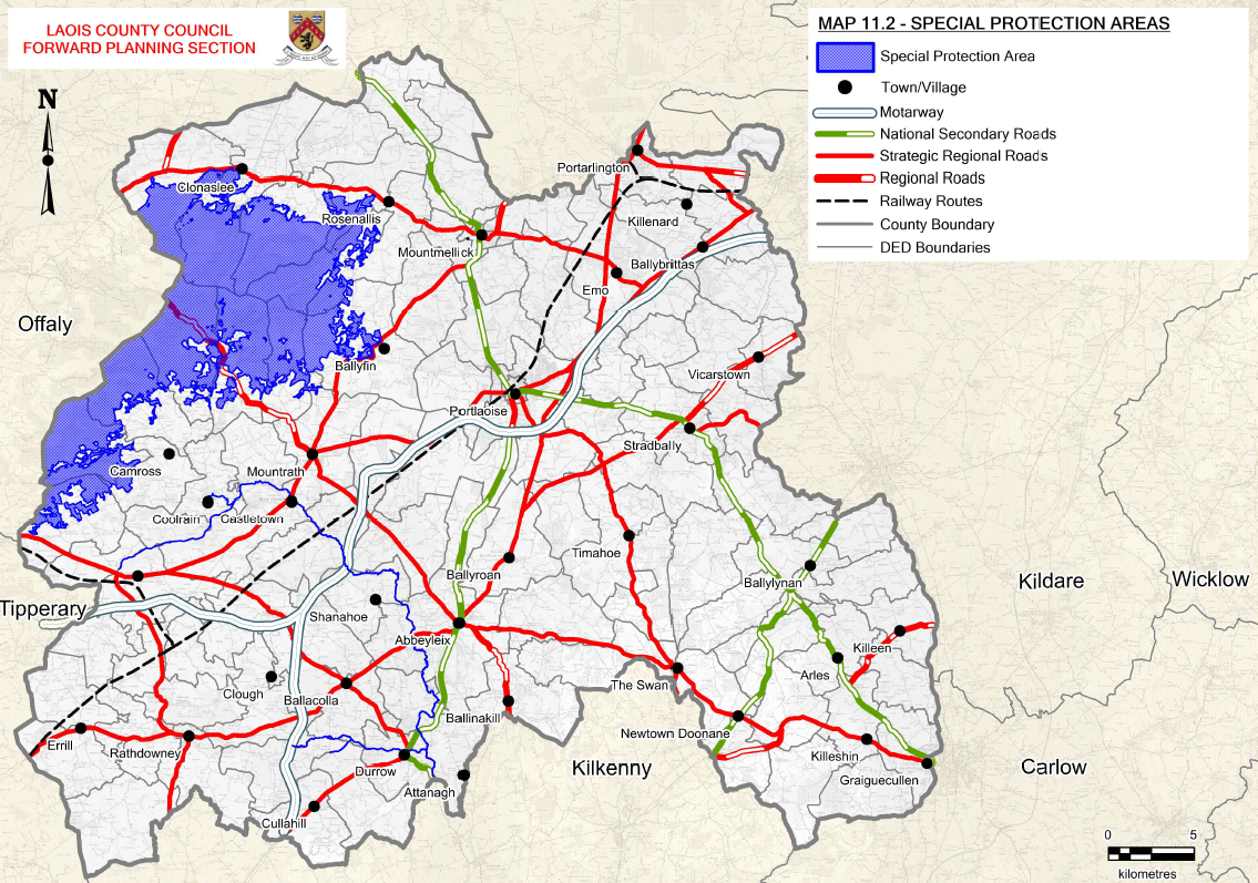
- 2 Special Protection Areas, SPAs (See Map 11.2)
- 2 Natural Heritage Areas, NHAs and 28 proposed Natural Heritage Areas (See Map 11.3)
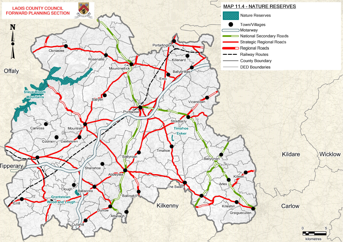
- 3 Statutory Nature Reserves (See Map 11.4).
“Natura 2000 sites” is the collective name given to Special Areas of Conservation (SACs) and Special Areas of Protection (SPA). These sites contain habitats or species of special European importance. Appropriate Assessment is a requirement of Articles 6(3) and 6(4) of Council Directive 92/43 /EEC on the conservation of natural habitats and of wild flora and fauna, also known as the Habitats Directive. The requirement for an appropriate assessment is not defined by the nature of the scale of the proposed development but solely by its potential to negatively impact on a Natura 2000 site. It is the responsibility of the proponent of a plan or project to carry out an AA at each stage of the proposed development in accordance with Article 6. Appropriate Assessment is not and should not be regarded as a prohibition on new development or activities but involves a case by case examination of the implications for Natura 2000 sites and its conservation objectives in a recorded step wise procedure.
11.4.1 SPECIAL AREAS OF CONSERVATION (SAC)
Special Areas of Conservation are prime wildlife areas, considered to be important on a European as well as Irish level. The legal basis on which SACs are selected and designated is the EU Habitats Directive (92/43/EEC), transposed into Irish law in the European Communities (Birds and Natural Habitats) Regulations 209-2015. The Directive lists certain habitats and species that must be protected within SACs. Irish habitats include raised bogs, blanket bogs, turloughs, sand dunes, machair, heaths, lakes, rivers, woodlands, estuaries and sea inlets. The species which must be afforded protection under the Habitats Directive include inter alia all our bat species, Salmon, Pearl Mussel, Common Frog, Pine Marten, Mountain Hare and Otter. There are eight SACs to date in County Laois noted in Table 11.1.
Table 11.1 Special Areas of Conservation in County Laois
|
Site Name |
Site Code |
|
Ballyprior Grassland |
002256 |
|
Clonaslee Eskers and Derry Bog |
000859 |
|
Coolrain Bog |
002332 |
|
Knockacoller Bog |
002333 |
|
Lisbigney Bog |
000869 |
|
Mountmellick |
002141 |
|
River Barrow And River Nore |
002162 |
|
Slieve Bloom Mountains |
000412 |
Map 11.1: Special Areas of Conservation
11.4.2 SPECIAL PROTECTION AREAS (SPA)
These are sites designated under the EU Birds Directive 79/409/EEC as a result of their importance for birds. There are two SPAs to date in County Laois, the Slieve Bloom Mountains SPA designated for the Hen Harrier, but also important for Merlin, Peregrine and Red Grouse and the River Nore SPA whose feature of interest is the Kingfisher.
Table 11.2 Special Areas of Protection in County Laois
|
Site Name |
Site Code |
|
Slieve Bloom Mountains |
004160 |
|
River Nore |
004233 |
Map 11.2: Special Protection Areas
11.4.3 NATURAL HERITAGE AREA (NHAS)
To date, only a selection of raised and blanket bog NHAs have been given formal legal protection. In County Laois, these sites are:
- 000652-Monaincha Bog / Ballaghmore Bog NHA
- 002357-Clonreher Bog NHA.
The remaining 28 proposed NHA (pNHA) sites in County Laois are given limited legal protection through; inter alia, recognition in the County Development Plan (See Table 11.3).
Map 11.3: Natural Heritage Areas
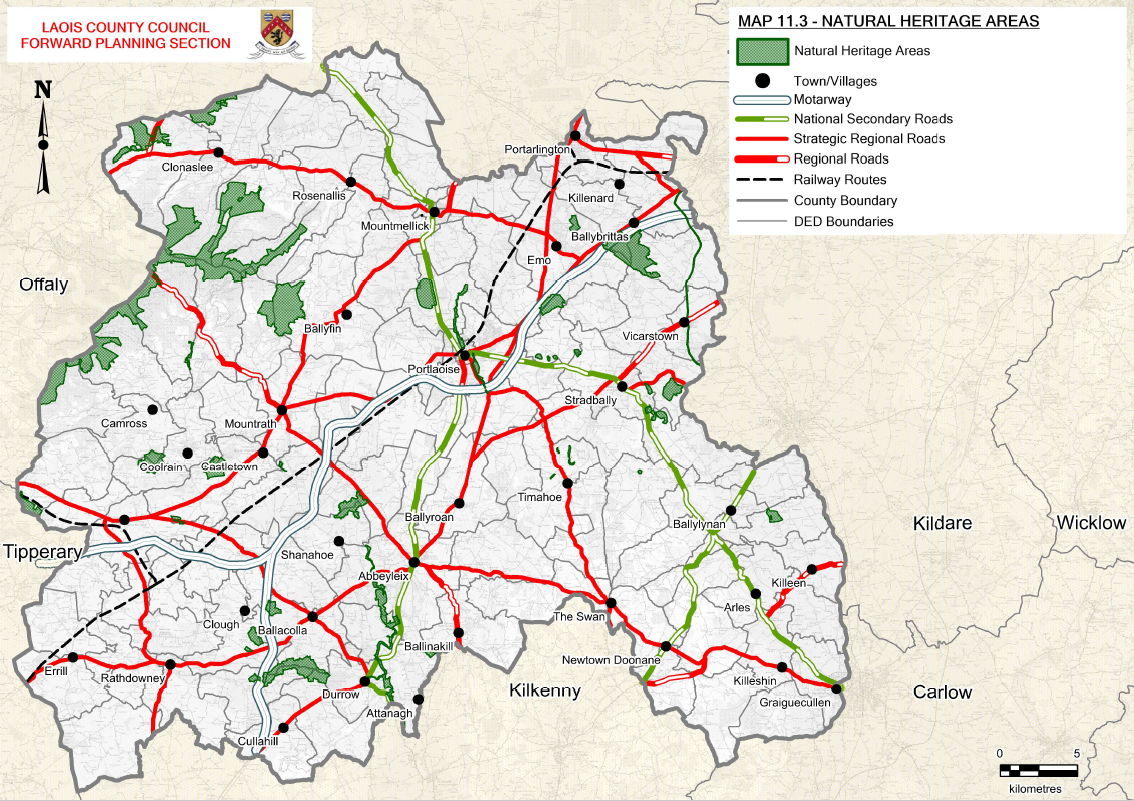
Table 11.3: Proposed Natural Heritage Areas (pNHAs)
|
SITE CODE |
MAIN HABITAT OR SPECIES |
|
|
Annaghmore Lough Fen |
000413 |
Calcareous fen with willow and birch scrub |
|
Ballylynan |
000857 |
Grassland, wet meadows |
|
Barrow Valley At Tankardstown Bridge |
000858 |
River, canal, grassland, marsh |
|
Clonaslee Eskers And Derry Bog |
000859 |
Esker, raised bog |
|
Clopook Wood |
000860 |
Ash/hazel woodland, limestone hill |
|
Coolacurragh Wood |
000862 |
Birch/alder woodland, fen peat |
|
Coolrain Bog |
000415 |
Midland raised bog (with Knockacoller Bog, these two bogs are the most southerly intact examples of true Midland Raised Bogs in the country) |
|
Cuffsborough |
000418 |
Grassland used by Greenland White-fronted geese |
|
The Curragh And Goul River Marsh |
000420 |
Wet meadow, river, winter feeding site for Greenland White-fronted Geese |
|
Delour River Nr Lacca Manor |
000864 |
Oak/birch woodland, river, wet grassland |
|
Derries Wood |
000416 |
Disturbed raised bog, disused gravel pit, conifer Plantation, lake, reedbed, important insect populations |
|
Dunamaise Woods |
001494 |
Limestone hills, oak/ash woodland |
|
Emo Court |
000865 |
Semi-natural mixed (oak/ash with beech) woodland, lake, parkland, amenity grassland |
|
Forest House Wood |
000874 |
|
|
Grand Canal |
002104 |
Canal, wetland, grassland |
|
Granstown Wood and Lough |
000417 |
State-owned nature reserve. Lake in transition through fen to alder/willow. Important invertebrate fauna |
|
Kilteale Hill |
000867 |
Limestone hill, hazel/ash woodland |
|
Knockacoller Bog |
000419 |
Midland raised bog, Birch and alder woodland. One of the few intact bogs south of the Slieve Blooms |
|
Lisbigney Bog |
000869 |
Raised bog |
|
Mannin Wetland |
00868 |
Species-rich fen |
|
Ridge Of Portlaoise |
000876 |
Esker ridge, ash/hazel woodland, species-rich grassland, disused gravel pits |
|
River Barrow And River Nore |
002162 |
River, wetland, woodland |
|
River Nore/Abbeyleix Woods Complex |
002076 |
River, site for Freshwater Pearl Mussel (international importance), Twaite Shad (Vulnerable), wet grassland, mixed deciduous woodland of great antiquity and species diversity, with specimen oak |
|
Rock of Dunamaise |
000878 |
|
|
Shanahoe Marsh |
001923 |
|
|
Slieve Bloom Mountains |
000412 |
Old Red Sandstone mountains, mountain blanket bog, Peregrine Falcon, Hen harrier, red grouse |
|
Stradbally Hill |
001800 |
|
|
Timahoe Esker |
000421 |
Esker ridge, Hazel/Ash woodland |
11.4.4 STATUTORY NATURE RESERVES
A Statutory Nature Reserve is an area of importance to wildlife, which is protected under Ministerial order. All four Statutory Nature Reserves in Laois are State-owned.
11.4.4.1 Grantstown Wood and Grantstown Lough Nature Reserve
These reserves are situated about 8km north-west of Durrow, County Laois and provide rare examples of wet woodland on base-rich soils, while Grantstown Lough is a classic example of a lake which has gradually infilled through fen to alder carr. Animals and plants of interest include Kingfishers, Cormorants and Otter. The wood is composed of native tree and shrub species, especially Oak, Ash, and Birch, along with Hawthorn, Guelder Rose, and Spindle.
11.4.4.2 Slieve Bloom Mountains Nature Reserve
This high mountain blanket bog, unlike many other bogs in Ireland, has been spared severe burning and grazing. It formed about six thousand years ago when the climate became wetter and bog began to blanket the mountain slopes. Animals and plants of interest include Ling Heather, Deer Grass and Sphagnum Moss. The mountains are important for populations of Red Grouse and Hen Harrier.
11.4.4.3 Timahoe Esker Nature Reserve
This is one of the few esker ridges left in the country which still carry native woodland. It is planned to expand the native woodland using appropriate management techniques.
11.4.4.4 Coolacurragh Wood
This reserve is an example of wet woodland on base-rich soils. It is dominated by alder, ash and birch with hawthorn in the shrub layer. The herb layer is dominated by bramble, nettle and meadowsweet. Fish in the lake provide Kingfishers, Cormorants and Otter with food.
Map 11.4: Nature Reserves
|
Policy Objectives for Biodiversity and Designated Sites |
|
|
BNH 1 |
Protect, conserve, and seek to enhance the county’s biodiversity and ecological connectivity |
|
BNH 2 |
Conserve and protect habitats and species listed in the Annexes of the EU Habitats Directive (92/43/EEC) (as amended) and the Birds Directive (2009/147/EC), the Wildlife Acts 1976 and 2010 (as amended) and the Flora Protection Orders. |
|
BNH 3 |
Support and co-operate with statutory authorities and others in support of measures taken to manage proposed or designated sites in order to achieve their conservation objectives. |
|
BNH 4 |
Protect and maintain the conservation value of all existing and future Natural Heritage Areas, Nature Reserves, Ramsar Sites, Wildfowl Sanctuaries and Biogenetic Reserves in the county. |
|
BNH 5 |
Projects giving rise to significant cumulative, direct, indirect or secondary impacts on Natura 2000 sites arising from their size or scale, land take, proximity, resource requirements, emissions (disposal to land, water or air), transportation requirements, duration of construction, operation, decommissioning or from any other effects shall not be permitted on the basis of this Plan (either individually or in combination with other plans or projects)[1]. Screening for AAs and AAs undertaken shall take into account invasive species as relevant. |
|
BNH 6 |
Assess, in accordance with the relevant legislation, all proposed developments which are likely to have a significant effect (directly or through indirect or cumulative impact) on designated natural heritage sites, sites proposed for designation and protected species. |
|
BNH 7 |
Protect Natural Heritage Areas (NHA) from developments that would adversely affect their special interests. |
|
BNH 8 |
Recognise and protect the significant geological value of sites in County Laois and safeguard these sites, in consultation with the Geological Survey of Ireland and in accordance with the National Heritage Plan and “Geological Heritage Guidelines for the Extractive Industry”. |
|
BNH 9 |
Engage with the National Parks and Wildlife Service to ensure Integrated Management Plans are prepared for all Natura sites (or parts thereof) and ensure that plans are fully integrated with the County Development Plan and other plans and programmes, with the intention that such plans are practical, achievable and sustainable and have regard to all relevant ecological, cultural, social and economic considerations and with special regard to local communities. |
|
BNH 10 |
Support the objectives of the All Ireland Pollinator Plan 2015-2020 by encouraging the planting of pollinator friendly trees and plants within grass verges along public roads and existing and future greenways, new hedgerows, public parks and public open spaces in towns and villages, including part of mixed use and residential developments |
|
BNH 11 |
Support measures to protect Swift population such as the creation of Swift nest cavities in all new commercial and public buildings (schools/libraries, etc) |
Development Management Standards
|
DM BNH 1 |
DEVELOPMENTS IN PROXIMITY TO PNHA Where a development is of a significant scale or in close proximity to a pNHA, the Council will require an Ecological Impact Assessment to determine the impact of the proposed development on the designated site or natural heritage. |
|
DM BNH 2 |
APPROPRIATE ASSESSMENT Article 6(3) and 6(4) of the Habitats Directive requires an Appropriate Assessment of any plan or project whether within or outside a designated Natura 2000 site, which does not directly relate to the management of the site but may impact upon its conservation objectives. All planning applications shall be screened for Appropriate Assessment and a Phase II Appropriate Assessment carried out if necessary. Where full Appropriate Assessment is required, the assessment shall be based on best scientific knowledge, by a person with ecological expertise. It shall address the potential impacts of the plan or project on the conservation objectives of any Natura 2000 site. The impacts assessed must include the indirect and cumulative impacts of approving the plan or project, considered with any current or proposed activities, developments or policies impacting on the site. The potential impacts of policies outside Natura 2000 sites but potentially impacting upon them (known as ‘ex situ’ impacts) must also be included in the assessment. (Refer to: Appropriate Assessment of Plans and projects in Ireland, Guidance for Planning Authorities, DEHLG (2009). |
11.5 GREEN INFRASTRUCTURE (GI)
Green Infrastructure is broadly defined as “as a strategically planned network of high quality natural and semi-natural areas with other environmental features, which is designed and managed to deliver a wide range of ecosystem services and protect biodiversity in both rural and urban settings[1]. Similarly Blue infrastructure refers to a network of assets which are linked to water such as rivers, canals, lakes, reservoirs, ponds and wetlands.
The GI network is a network of parks, green spaces, gardens, woodlands, rivers and wetlands, as well as urban greening features such as street trees and green roofs, which is planned, designed and managed as a multifunctional resource capable of delivering a wide range of economic, environmental and quality of life benefits for local communities:
- promote healthier living, providing spaces for physical activity and relaxation
- address climate change adaptation
- create a strong sense of place
- filter pollutants to improve air and water quality
- make streets clean, comfortable and more attractive to encourage walking and cycling
- store carbon in soils and woodlands
- create better quality and better-connected habitats to improve biodiversity and resilience
- promote local food production in allotments and gardens
The multiple benefits of GI are recognised in a number of national policy documents:
- The National Biodiversity Plan sees GI as crucial to achieving biodiversity targets and developing ecological corridors that allow the movement of species through their entire natural habitat.
- The Strategy for the Future Development of National and Regional Greenways focuses on the economic and social benefits of creating and connecting greenways, particularly in rural areas.
- The Flood Risk Management Guidelines highlight GIs key role in managing flood risk and adapting to climate change.
The Regional Spatial and Economic Strategy for the Eastern and Midlands Region recognises the strategic importance of developing GI assets across the region with specific objectives (RPO 7.22 and 7.23) that development plans and local area plans shall identify, protect, enhance, provide and manage Green Infrastructure in an integrated and coherent manner. Linking strategic natural assets with cultural and heritage assets further enhances the opportunities for GI strategies to drive recreation and tourism benefits
The Regional Spatial and Economic Strategy for the Eastern and Midlands Region recognises the strategic importance of developing GI assets across the region with specific objectives (RPO 7.22 and 7.23) that development plans and local area plans shall identify, protect, enhance, provide and manage Green Infrastructure in an integrated and coherent manner. Linking strategic natural assets with cultural and heritage assets further enhances the opportunities for GI strategies to drive recreation and tourism benefits.
Specific to County Laois, the following GI, Cultural and Natural assets have been identified:
Table 11.4 Strategic Natural Assets
|
ASSET |
LOCATION |
|
Lakes, Rivers and Canals |
River Barrow, River Nore |
|
Greenways, Blueways and Peatways |
Barrow Blueway |
|
Uplands, Woodlands and Designated Sites |
Slieve Blooms (all SACs, SPAs, NHAs, pNHAs and Ramsar sites) |
|
Boglands and Peatlands |
Abbeyleix Bog |
|
National and Regional Parks |
Emo Court, Heywood Gardens |
|
Medieval, Historic and Walled Towns |
Abbeyleix |
|
Heritage Sites |
Sites on Record on National Monuments |
11.5.1 URBAN GREEN INFRASTRUCTURE
In towns and villages, GI is a patchwork of natural areas that provides habitat, flood protection, cleaner air and cleaner water. Each town and village in the County should include urban GI to create corridors between and link green spaces, creating healthier environments and a greater sense of place. The following elements, many of which are sustainable Urban Drainage Systems, can be integrated into sites to create GI at an urban scale:
- Rainwater Harvesting/Bioswales
- Planter Boxes/Permeable Pavements
- Green Streets/Green Parking
- Green Roofs and Living Walls
- Urban Tree Canopy
11.5.2 GREEN INFRASTRUCTURE STRATEGY FOR LAOIS
It is the Council’s intention to develop a Green Infrastructure Strategy for the County in consultation will all key stakeholders and with the public during the lifetime of this Plan. The Strategy will identify key Green Infrastructure aims and objectives for the County taking account of the priority projects identified in this Plan and it will provide for the delivery of these projects including the provision of appropriate funding mechanisms.
|
Policy Objectives for Green Infrastructure |
|
|
BNH 11 |
Ensure that areas and networks of Green Infrastructure are identified, protected, enhanced, managed and created to provide a wide range of environmental, social and economic benefits to communities. |
|
BNH 12 |
Develop and implement a Green Infrastructure Strategy for Laois in partnership with key stakeholders and the public which reflects a long-term perspective, including the need to adapt to climate change. Ensure the Green Infrastructure Strategy for Laois protects existing Green Infrastructure resources and plans for future Green Infrastructure provision |
|
BNH 13 |
Require all Local Area Plans and Master Plans to protect, enhance, provide and manage Green Infrastructure in an integrated and coherent manner. Set targets for the provision of Green Infrastructure elements such as trees and green roofs as part of the preparation of Local Area Plans. |
|
BNH 14 |
Promote a network of paths and cycle tracks to enhance accessibility to the Green Infrastructure network, while ensuring that the design and operation of the routes respect and where possible enhances the ecological potential of each site |
|
BNH 15 |
Encourage, pursuant to Article 10 of the Habitats Directive, the management of features of the landscape, such as traditional field boundaries and laneways, important for the ecological coherence of the Natura 2000 network and essential for the migration, dispersal and genetic exchange of wild species. |
|
BNH 16 |
To identify and map Green Infrastructure assets and sites of local biodiversity value over the lifetime of the Plan. |
Green Infrastructure Development Management Standard
|
DM BNH 3 |
GREEN INFRASTRUCTURE PLAN Require all proposals for large scale development such as road or drainage schemes, wind farms, housing estates, industrial parks or shopping centres to submit a Green Infrastructure Plan as an integral part of a planning application. |
11.6 TREES, WOODLANDS AND HEDGEROWS
11.6.1 TREES AND WOODLANDS
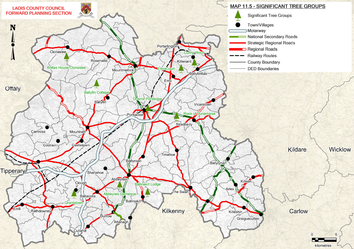
Trees play a crucial role in capturing pollutants and particulates from the air. Street trees can significantly improve air quality, which can in turn provide health benefits, if planned, planted and maintained carefully. Carbon storage relates to the carbon currently held in trees’ tissue (roots, stem, and branches), whereas carbon sequestration is the estimated amount of carbon removed annually by trees. Trees can help mitigate climate change by sequestering atmospheric carbon as part of the carbon cycle. Trees and woodlands make a positive contribution to the county’s landscape biodiversity and townscapes providing wildlife habitats, soften hard urban edges and provide scale and backdrops to streets and buildings. Trees, either individually or in groups also make an important contribution to the landscape of many of the country house demesnes throughout the county. In urban settings trees or groups of trees can contribute significantly to the local landscape or townscape and to the successful integration of new buildings into the landscape. The planting or retention of mature trees can contribute to amenity and more attractive developments as well as providing important wildlife habitats. The retention of trees should be considered at the design stage of any development. They also filter out noise, dust and pollutants and prevent flooding by retaining moisture. A number of important tree groups have been identified in Map 11.5 and will be considered for Tree Preservation Orders (TPOs) during the Plan period. Further assessment of important trees and groups of trees will also be considered during Local Area Plan reviews.
Map 11.5: Trees, Views and Prospects
11.6.2. HEDGEROWS
Hedgerows define rural landscapes and are valuable for terrestrial forms of wildlife. They are particularly important for birds and woodland plants. They provide commuting and feeding corridors for bats. Where they are found in settlements they are significant habitats and corridors for biodiversity.
Hedgerows also provide effective farmland barriers and boundaries, as well as vital habitats and landscape corridors for a vast array of native plants and wildlife. Most hedgerows were planted over the last 300 years or so following the enactment of legislation in the 18th century requiring landowners to enclose their land. However, heritage hedgerows which are considerably older than the majority of hedgerows often have strong links with native woodland that date back thousands of years and are of even greater biodiversity and historical value. Good hedgerows can easily be identified by their structure and location in the landscape. Best quality hedgerows will have all the following characteristics:
- A few mature trees,
- A three tier structure (with trees, shrubs and herbs)
- Few gaps and
- Will not have been cut into a box shape. Shrubs (almost always) include hawthorn, blackthorn or and possibly dog rose.
- The herb layer is found under the shrub layer. It should form a strip of tall grassland along the margin of the hedgerow.
There is an extensive network of hedgerows throughout County Laois. There will be a firm presumption against the removal of hedgerows to facilitate development including where sight lines are deficient. In cases where removal is necessary, the planting of an equivalent length of native hedgerow will be required as a condition of planning permission. Further policy objectives in relation to the management of hedgerows for development is also provided in Chapter 4 Housing and Chapter 10 Infrastructure.
|
Policy Objectives for Trees, Woodlands and Hedgerows |
|
|
BNH 17 |
Undertake a study within the lifetime of the Plan and for all Local Area Plans to document and map trees and groups of trees that require preservation and prepare Tree Preservation Orders for individual trees, groups of trees or woodland areas where expedient and in the interests of visual amenity, biodiversity and the environment. |
|
BNH 18 |
Protect individual trees, groups of trees and woodland in the interests of landscape conservation (including townscapes) and nature conservation as part of the development management process |
|
BNH 19 |
Protect existing hedgerows, particularly of historical and archaeological importance of townland boundaries, from unnecessary removal in order to preserve the rural character of the countryside ad promote biodiversity |
|
BNH 20 |
Ensure that hedgerow removal to facilitate development is kept to an absolute minimum and, where unavoidable, a requirement for mitigation planting will be required comprising a hedge of similar length and species composition to the original, established as close as is practicable to the original and where possible linking in to existing adjacent hedges. Native plants of a local provenance should be used for any such planting |
|
BNH 21 |
Promote and develop urban forests in parkland and street trees in urban settlements to enhance public realm and increase tree canopy coverage and diversity. |
|
BNH 22 |
Ensure that hedgerow and mature tree removal to facilitate development is kept to an absolute minimum and, where unavoidable, a requirement for mitigation planting will be required comprising a hedge of similar length and species composition to the original, established as close as is practicable to the original and where possible linking in to existing adjacent hedges. Native plants of a local provenance should be used for any such planting |
Trees, Woodland and Hedgerows Development Management Standards
|
DM BNH 4 |
MATURE TREES Where there are trees within an application site, or on land adjacent to it that could influence or be affected by proposed development (including street trees), the planning application must include a detailed submission prepared by a suitably qualified Arboriculturist in accordance with British Standard 5837: 2012 ‘Trees in relation to design, demolition and construction – Recommendations’. A Tree Management Plan shall be provided to ensure that trees are adequately protected during development and incorporated into the design of new developments. |
|
DM BNH 5 |
HEDGEROWS In dealing with applications for new developments, the Planning Authority will have regard to the following:
|
11.7 WATERWAYS AND WETLANDS
The rivers and streams, lakes, wetlands and groundwater occurring within County Laois are home to a variety of habitats and species. Wetlands associated with rivers and streams, such as wet grasslands and marshes, are important for biodiversity and to help manage fluvial and pluvial flooding whilst supporting a quality, multi-functional green network generating multiple benefits for the environment, tourism and society.
The waterways of County Laois include the Barrow, Nore and Erkina which flow in a northwest-southeast trajectory and there are minor man-made lakes at Ballyfin, Grantstown and Heywood. The Barrow Blueway Project which is set to begin works in July 2020, is a coordinated project between Waterways Ireland, Laois County Council and Kildare County Council of the River Barrow Navigation system from Lowtown in Kildare, through the towns of Rathangan, Monasterevin, and Vicarstown to Athy. The planned upgrade is to provide a multi-use shared 46km off-road, flat accessible, public space and leisure route. In time this route could extend on to St Mullins in Carlow.
The Grand Canal is a key element of Green Infrastructure in the County also passes through the north east of the county where it links to the wider River Barrow navigation system, the towpath of which provides an uninterrupted corridor for pedestrians and cyclists. The Mountmellick Line of the Grand Canal, built between 1827 and 1831, runs from the Barrow Line at Monasterevin via Portarlington to Mountmellick.
Wetland habitats are an important source of biodiversity and contain species such as otters (Lutra lutra), Salmon (Salmo salar), Kingfishers (Alcedo atthis), Freshwater crayfish (Austropotamobius pallipes ) and Lamprey species, all protected under the Wildlife Acts of 1976 and 2000 and/or listed on the annexes of the EC Habitats Directive and Birds Directive. County Laois is particularly important for the Nore Pearl Mussel “Margaritifera durrovensis” and special mention is made of this species throughout the Plan and SEA. The species is protected under the Freshwater Pearl Mussel Nore Sub-Basin Management Plan [2009]. The Slieve Bloom Mountains are also designated as a Ramsar Site which is a site designated internationally for the conservation of wetlands, particularly those of importance to waterfowl under The Convention on Wetlands of International Importance especially as Waterfowl Habitat, the so-called Ramsar Convention.
|
Policy Objectives for Waterways and Wetlands |
|
|
BNH 23 |
Protect waterbodies and watercourses from inappropriate development, to ensure they are retained for their biodiversity and flood protection values and to conserve and enhance where possible, the wildlife habitats of the County’s rivers and riparian zones, lakes, canals and streams which occur outside of designated areas to provide a network of habitats and biodiversity corridors throughout the county. |
|
BNH 24 |
Promote and develop the Barrow Blueway initiative and work with State Agencies, landowners, local communities and other relevant groups to protect and manage inland waters, river corridors and their floodplains from degradation and damage, and to recognise and promote them as natural assets of the urban and rural environment |
|
BNH 25 |
Facilitate the development of the Grand Canal for cycling, walking and nature study. Investigate the possibility of developing long distance walking routes/Greenway, within the lifetime of the Plan, along the disused Mountmellick Grand Canal Line. |
|
BNH 26 |
Protect riparian corridors by reserving land along their banks for ecological corridors and maintain them free from inappropriate development. Where developments are proposed adjacent to waterways in previously undeveloped areas, the Planning Authority will require a general setback distance of a minimum of 10 metres from the waterways edge, subject to site-specific characteristics and the nature and design of the development. In previously developed areas, for example, within town centres, this general setback distance is likely to be reduced and should be part of any pre-planning consultations with the Council. |
|
BNH 27 |
Require that development along rivers set aside lands for pedestrian routes and cycleways that could link to the broader area and established settlements in the area. |
|
BNH 28 |
Provide for public access to waterways where feasible and appropriate, in partnership with the National Parks and Wildlife Service (NPWS), Waterways Ireland and other relevant stakeholders, whilst maintaining them free from inappropriate development, subject to Ecological Impact Assessment and Appropriate Assessment, as appropriate. |
|
BNH 29 |
Protect the Nore Pearl Mussel through the measures set out in the Freshwater Pearl Mussel Nore Sub-Basin Management Plan (2009). |
|
BNH 30 |
Protect the migration of fish in the River Barrow Nore SAC from high risk barriers such weirs and bridge sills. |
11.8 Peatlands
Peatlands are one of the world’s most important ecosystems, covering a mere 3% of the world’s terrestrial surface and 20% of Ireland’s land area, containing 550 gigatonnes of carbon, making them the most important long term carbon sinks in the terrestrial biosphere. Peatland rehabilitation will also bring additional benefits of improving water quality and flood attenuation to downstream water-courses.
The majority of larger peatland areas in the county are located in the north west within the Slieve Blooms and mid area of the County to the south and south west of Portlaoise. Approximately 3,000 ha of peatland is under the ownership of Bord Na Mona with much of the land utilised for industrial peat extraction for decades and consequently much of the overlying peat deposits has been cutaway.
As Bord Na Mona transition away from commercial peat production and decarbonise business structures, the rehabilitated cutaway will naturally revert to a rich and diverse natural habitat enhancing biodiversity and supporting other ecosystem services by integrating other sustainable land-uses, including renewable energy and Green Infrastructure.
Examples of Bord na Móna enabled Green Infrastructure in the county include the restored Abbeyleix bog (190ha), which is now leased to the local community as a conservation project and forms part of a Natural Walking Loop. Bord na Móna also restored Knockahaw Bog (Errill Bog) in 2018 as part of its Biodiversity Action Plan and peatland rehabilitation commitments. Knockahaw Bog is a relatively large restored raised bog of 312 ha located on the south east range of raised bog distribution in Ireland. Both Abbeyleix Bog and Knockahaw Bog are examples of high value biodiversity sites which can be prioritsed for similar tracts of boglands.
Further details on the reuse of pealtlands are provided in Section 9.4 of the Plan.
|
Policy Objectives for Peatlands |
|
|
BNH 31 |
The County Development will continue to support the objectives of the Strategic Framework for the Future use of Peatlands which identifies new potential future land uses and also seek to progress opportunities under Just Transition Fund. |
|
BNH 32 |
Protect the county’s designated peatland areas and landscapes and to conserve their ecological, archaeological, cultural, and educational heritage. |
|
BNH 33 |
Work with relevant agencies such as Eastern and Midland Regional Assembly, Bord na Mona, NPWS, Coillte and adjacent Local Authorities to prepare an integrated afteruse framework and management plans for the peatlands and related infrastructure, |
|
BNH 34 |
Support the preparation of a Sustainable Holistic Management Plan for the future use of the Industrial Peatlands in the County, which recognises the role of peatlands in carbon sequestration. |
|
BNH 35 |
Support the designation of a National Park for the peatlands area in the Midlands in conjunction with adjoining Local Authorities. |
|
BNH 36 |
Undertake a feasibility study to identify peatways, where appropriate and examine the tourist potential of same such as a peatway link from Portarlington to the Grand Canal and River Barrow Greenway. |
|
BNH 37 |
Support relevant agencies to provide for the future sustainable and environmentally sensitive use of large industrial peatlands at Cuil Na Mona. |
Development Management Standard for Peatlands
|
DM BNH 6 |
PEATLANDS In the consideration of development on or adjacent to peatland areas, the following guiding principles should apply:
|
11.9 PUBLIC RIGHTS OF WAY
As the population of the county grows and people become more aware of the importance of our built and natural heritage, the issue of access to the countryside and to heritage sites has become increasingly important. The formal process for designating rights of way is outlined in Section 14 of the Planning and Development Act 2000 (as amended).
Section 10(2)(o) of the Planning and Development Acts 2000 as amended state that a Development Plan shall include an objective for ‘the preservation of public rights of way which give access to seashore, mountain, lakeshore, riverbank or other place of natural beauty or recreational utility, which public rights of way shall be identified both by marking them on at least one of the maps forming part of the development plan and by indicating their location on a list appended to the development plan’.
Existing public rights of way constitute an important amenity and the Council recognises the importance of maintaining established public rights of way and supporting initiatives for establishing walking routes in the county.
This is, by its nature, a lengthy process which will be conducted throughout the lifetime of this Development Plan. Table 11.5 below provides a list and Map 11.6 shows the extent and location of such public rights of ways, identified to date, in accordance with this provision. It is important to note that this is not an exhaustive list and that the omission of a public right of way from this list shall not be taken as an indication that such a right of way is not a public right of way.
Map 11.6: Public Rights of way
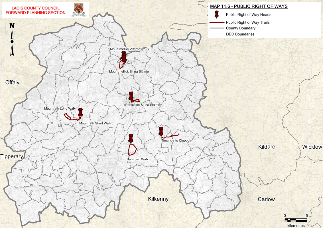
Table 11.5: Public Rights of Way in County Laois
|
Ref No. |
Public Rights of Way |
Description |
|
PRW 1 |
Mountmellick Sli Na Slainte |
Footpath and public road |
|
PRW 2 |
Mountmellick Alternative Sli |
Footpath and public road |
|
PRW 3 |
Timahoe to Clopook |
Forest and road walk |
|
PRW 4 |
Mountrath Long Walk |
Road walk |
|
PRW 5 |
Ballyroan Walk |
River and road walk |
|
PRW 6 |
Portlaoise Sli na Slainte |
Footpath and public road |
There are significant stretches of land that were formerly in use as railway lines within the county / region.
To the extent that these are engineering works negotiating difficult topographical obstacles, they constitute significant resources, with potential for use as corridors for amenity access, free from motorised traffic, and even have potential for a revived railway use. The Council encourages the consideration of proposals for development in these areas for local heritage and outdoor activities including the provision of recreational walkways or cycling routes.
|
Policy Objectives for Public Rights of Way |
|
|
BNH 38 |
Preserve public rights of way which give access to, mountain, lakeshore, riverbank or other place of natural beauty or recreational utility indicated in Map 11.6 of the Plan |
|
BNH 39 |
Review and protect existing public rights of way for the common good and bring forward proposals for the creation of public rights of way. Ensure that Public Rights of Way are well marked and signposted |
|
BNH 40 |
Development will not be permitted where a public right of way will be affected unless the level of amenity loss is minimised by:
|
11.10 Landscape
Landscape Character Assessment (LCA) is a process that describes, maps and classifies landscapes objectively. Defining landscape character enables an understanding to be formed of the inherent value and importance of individual landscape elements and the processes that may alter landscape character into the future.
Laois County Council has prepared a Landscape Character Assessment to identify specific areas that are characterised by sensitive landscapes. (See Figure 11.6) Sensitive areas include upland areas, visually open and expansive areas and areas in the vicinity of natural heritage or built heritage assets or scenic views.
The Assessment will help developers select less sensitive sites for development. Landscape Character Types are distinct types of landscape that are relatively homogenous in character. They are generic in nature in that they may occur in different localities throughout any defined area. Nonetheless, where they do occur, they commonly share similar combinations of geology, topography, land cover and historical land use. For example, blanket bog uplands are distinct landscape character types and are recognisable as such whether they occur in County Laois or other counties.
The Landscape Character Areas for County Laois are as follows and are identified in Map 11.7. Table 11.6 also classifies the sensitivity of each area when assessing development.
- Hills and Upland
- Lowland Agricultural Areas
- River Corridors and Lakes
- Mountain Areas
- Peatland Areas
- Urban Fringes
- Rolling Hills
Map 11.7: Landscape Character Assessment
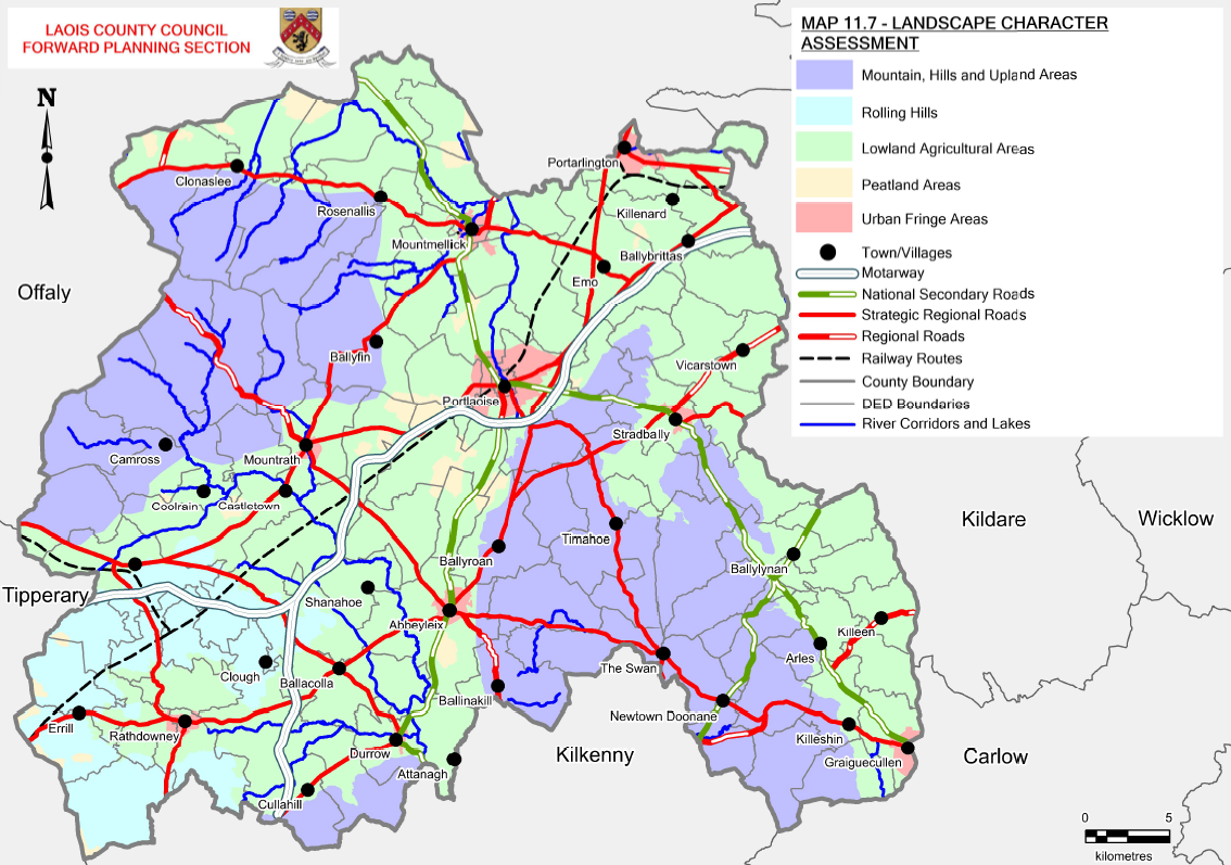
Table 11.6: Landscape Sensitivity
|
Sensitivity |
Landscape Character Area and Special Features
|
Description |
|
Low Sensitivity |
Lowland Agricultural Areas, Urban Fringes |
Areas with the capacity to generally accommodate a wide range of uses without significant adverse effects on the appearance or character of the area |
|
Medium Sensitivity |
Rolling Hills and Hills and Upland Areas |
Areas with the capacity to accommodate a range of uses without significant adverse effects on the appearance or character of the landscape having regards to localised sensitivity factors |
|
High Sensitivity |
Peatlands, River Corridors and Lakes, Mountain Areas, European Sites |
Areas with reduced capacity to accommodate uses without significant adverse effects on the appearance or character of the landscape having regard to prevalent sensitivity factors or special sensitivity factors |
|
Policy Objectives for Landscape Character Areas |
|
|
LCA 1 |
Ensure that consideration of landscape sensitivity, as indicated in Table 11.6 of the Plan, is an important factor in determining development uses In areas of high landscape sensitivity, the design, type and the choice of location of proposed development in the landscape will also be critical considerations |
|
LCA 2 |
Protect and enhance the county’s landscape, by ensuring that development retains, protects and, where necessary, enhances the appearance and character of the existing local landscape and conserve valuable habitat including any European and National Designations |
|
LCA 3 |
Seek to ensure that local landscape features, including historic features and buildings, hedgerows, shelter belts and stone walls, are retained, protected and enhanced where appropriate, so as to preserve the local landscape and character of an area, whilst providing for future development |
|
LCA 4 |
Seek to minimise the individual and cumulative adverse visual impacts that local concentrations of one-off housing, outside of settlements, may have on Hills and Upland, River Corridor and Lakes and Mountain landscape character areas or High Sensitivity areas. In this regard, in locations where the Council considers that there is a risk of individual or cumulative adverse impacts, the Council will only consider proposals for housing developments where a need for the dwelling has been demonstrated in accordance with the criteria contained in the Rural Housing Policy contained in Chapter 4 |
|
Policy Objectives for Hills and Uplands Areas and Mountain Areas |
|
|
LCA 5 |
Ensure that development will not have a disproportionate visual impact (due to excessive bulk, scale or inappropriate siting) and will not significantly interfere with or detract from scenic upland vistas, when viewed from areas nearby, scenic routes, viewpoints and settlements |
|
LCA 6 |
Ensure that developments on steep slopes (i.e. >10%) will not be conspicuous or have a disproportionate visual impact on the surrounding environment as seen from relevant scenic routes, viewpoints and settlements |
|
LCA 7 |
Facilitate, where appropriate, developments that have a functional and locational requirement to be situated on steep or elevated sites (e.g. reservoirs, telecommunication masts or wind energy structures) where residual adverse visual impacts are minimised or mitigated |
|
LCA 8 |
Maintain the visual integrity of areas which have retained a largely undisturbed upland character and Respect the remote character and existing low-density development in these areas. |
|
LCA 9 |
Have regard to the potential for screening vegetation when evaluating proposals for development within the uplands |
|
LCA 10 |
Actively propose the designation of the Slieve Blooms as a Special Amenity Area and seek an Order to that effect. |
|
LCA 11 |
Protect the positive contribution that views across adjacent lowland areas and landmarks within the landscape make to the overall landscape character |
|
Policy Objectives for Lowland Agricultural Areas |
|
|
LCA 12 |
Recognise that this lowland landscape character area includes areas of significant landscape and ecological value, which are worthy of protection, particularly the 18th and 19th century estate landscapes and associated parkland & woodland to develop them as a tourism resource. |
|
LCA 13 |
Continue to permit development that can utilise existing structures, settlement areas and infrastructure, whilst taking account of the visual absorption opportunities provided by existing topography and vegetation |
|
LCA 14 |
Recognise that the lowlands are made up of a variety of working landscapes, which are critical resources for sustaining the economic and social wellbeing of the county |
|
LCA 15 |
Promote good agricultural practices to create a sustainable rural economy and support incentives for smaller rural/family farms to manage their land to avoid loss of hedgerows and field patterns. |
|
Policy Objectives for River Corridors and Lakes Areas |
|
|
LCA 16 |
Recognise the importance of river corridors for scenic value, ecology, history, culture and for recreational purposes such as walking, cycling and various on-water activities; |
|
LCA 17 |
Maintain the rivers throughout the county whilst ensuring that all works are carried out subject to appropriate environmental assessment in accordance with Article 6 of the Habitats Directive, in respect of any proposed development likely to have an impact on a designated natural heritage site, site proposed to be designated and any additional sites that may be designated during the period of this Plan |
|
LCA 18 |
Preserve riverside historic features and their landscape settings and Conserve valuable habitats focused on and around river corridors and estuaries including European and national designations |
|
LCA 19 |
Recognise the potential constraints on development created by river flood plains and the value of these flood plains as increasingly rare habitats |
|
LCA 20 |
Avoid unsustainable exploitation of watercourses, e.g. for abstraction and dilution of effluent, to the point that these water courses lose their ecological and amenity value |
|
LCA 21 |
Collaborate with the National Parks and Wildlife Service, Waterways Ireland and other relevant stakeholders to facilitate public access to waterway corridors and maintain and enhance the natural character of rivers, lakes and canals by reserving land to facilitate walking, cycling and other non-noise generating recreational activities |
|
LCA 22 |
Explore the establishment of the Barrow/Nore Valley and the Grand Canal as Areas of Special Amenity, as per section 202 of the Planning and Development Act 2000 (as amended) |
|
Policy Objectives for Peatland Areas |
|
|
LCA 23 |
Recognise the importance of peatlands for ecology, history, culture and for alternative energy production |
|
LCA 24 |
Conserve valuable habitats including any European and national designations |
|
LCA 25 |
Support the identification of projects that have the potential to achieve commercial value such as industrial developments, renewable energy, tourism developments etc. while at the same time promoting high environmental standards and supporting Biodiversity objectives |
|
LCA 26 |
Support the restoration of peatlands on suitable sites |
|
LCA 27 |
Recognise that intact boglands are critical natural resources for ecological and environmental reasons and recognise that cutaway and cut-over boglands represent degraded landscapes and/or brownfield sites and thus are potentially robust to absorb a variety of appropriate developments |
|
Policy Objectives for Urban Fringe Areas |
|
|
LCA 28 |
Diversify the urban fringe by developing mixed-use amenity areas, which will create a landscape buffer creating a transition between urban and rural areas |
|
LCA 29 |
Define the urban fringe with planting of native species and mixed woodland to tie into existing rural landscape |
|
Policy Objectives for Rolling Hill Areas |
|
|
LCA 30 |
Maintain the visual integrity of rolling hill areas which have retained an upland character |
|
LCA 31 |
Continue to facilitate appropriate development, in an incremental and clustered manner, where feasible, that respects the scale, character and sensitivities of the local landscape, recognising the need for sustainable settlement patterns and economic activity within the county |
|
LCA 32 |
Continue to permit development that can utilise existing infrastructure, whilst taking account of local absorption opportunities provided by the landscape, landform and prevailing vegetation |
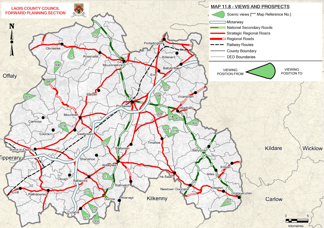
11.10.1 VIEWS AND PROSPECTS
Scenic routes and protected views consist of important and valued views and prospects within the county. Table 11.7 below, lists the specific scenic views of the landscape, many of which are located along scenic routes and include built and archaeological features. Map 11.8 also indicates such scenic views within the county. The Council recognises the need to protect the character of the county by protecting views and scenic routes. However, it is acknowledged that in certain circumstances, some development may be necessary.
Table 11.7: Scenic Views and Prospects in County Laois
|
No. |
View From |
View To |
|
001 |
Road No. L3896 in the townlands Killeshin, Rossmore |
Views towards lowlands of Graiguecullen/Carlow |
|
002 |
N80 in the townlands of Stradbally [The Windy Gap] |
Views of the Windy Gap |
|
003 |
N80 in the townlands of Stradbally |
Views of the Windy Gap |
|
004 |
Road No. L5753 in the townlands Cullahill |
Views towards Knockmannon Hill |
|
005 |
Road No. L1005 in the Slieve Bloom Mountains |
Slieve Bloom Mountains views towards Clodiagh River over lowlands |
|
006 |
Road No. L1005 in the Slieve Bloom Mountains |
Slieve Bloom Mountains views towards Delour River over lowlands |
|
007 |
Road No. L10317 in the Slieve Bloom Mountains |
Slieve Bloom Mountains, Killeen River |
|
008 |
N80 in the townlands of Stradbally, Portlaoise |
Views towards Rock of Dunamaise |
|
009 |
N80 in the townlands of Stradbally, Portlaoise |
Views towards Hewson Hill |
|
010 |
N80 in the townlands of Mountmellick |
Views towards Slieve Bloom Mountains |
|
011 |
R445 in the townlands of The Heath |
Views towards Carrigeen Hill |
|
012 |
The village lands of Raheen |
Views over farmland |
|
013 |
N77 in the townlands of Abbeyliex, Durrow |
Views over farmland and River Nore |
|
014 |
R639 in the townlands of Cullahill, Durrow |
Views towards Caponellan Hill |
|
015 |
R639 in the townlands of Cullahill, Durrow |
Views over farmland and River Goul |
|
016 |
R445 in the townlands of Castletown |
Views over farmland and Slieve Bloom Mountains |
|
017 |
R422 in the townlands of Clonaslee |
Views over farmland and Slieve Bloom Mountains |
|
018 |
N80 in the townlands of Stradbally |
Views over farmland and River Bauteogue |
|
019 |
Road No. L3840 in the townlands of Timahoe |
Views over farmland and Hewson Hill |
|
020 |
Road No. L3840 in the townlands of Timahoe |
Views over farmland and Ballaghmore Hill |
|
021 |
Road No. L5757 in the townlands of Clonaslee |
Views of Cullahill Castle and Knockmannon Hill |
Map 11.8: Scenic Views and Prospects
|
Policy Objectives for Views and Prospects |
|
|
SV 1 |
Protect views from designated scenic routes indicated in Table 11.7 and Map 11.8 (Scenic Views and Prospects in County Laois) of the Plan, by avoiding any development that could disrupt the vistas or disproportionately impact on the landscape character of the area, thereby affecting the scenic and amenity value of the views. |
|
SV 2 |
Review and update all Scenic Routes and Views in the county during the lifetime of the Plan. |
11.11 GEOLOGY
Geology is an intrinsic component of the natural heritage of Laois. The Geological Survey of Ireland established the Irish Geological Heritage Programme in 1998. The programme identifies and selects the very best national sites for NHA designation, to represent the country's geology. It is also identifies many sites of national or local geological heritage importance, which are classed as County Geological Sites (CGS). These sites will be protected primarily through their inclusion in the County Development Plan.
The Council recognises that Geology is an intrinsic component of natural heritage within the Planning Acts and Regulations and the Heritage Act 1995 to be protected and promoted for its heritage value and for its potential for recreational and geo-tourism initiatives and that it must ensure that geological heritage is adequately addressed in Development Plans.
While the most important geological sites and geomorphological scientific sites will be designated as NHAs the National Heritage Plan (2002) has recommended the recognition and protection of other important sites known as County Geological Sites. The Irish Geological Programme (a partnership between the GSI and NPWS) identifies CGs, that although of national, regional and local importance will not receive the statutory protection of NHA sites.
|
Policy Objectives for Geology |
|
|
GEO 1 |
Work with stakeholders to protect, preserve, enhance, maintain, manage, conserve, recognise and, where appropriate, restore the character conservation value and integrity of these sites for their amenity, scientific, heritage and historic values (including County Geological Sites listed in Table 28, proposed NHA’s, areas near site and areas of geomorphological interest |
|
GEO 2 |
Protect geological NHAs as they become designated and notified to the Local Authority, during the lifetime of the Plan; |
|
GEO 3 |
Encourage, where practicable and when not in conflict with ownership rights, access to geological and geomorphological features |
|
GEO 4 |
Encourage and facilitate the development of geo-tourism by conserving and managing geological resources, and by the development of a Rock Trail (named), Geoparks or other similar geo-tourism initiatives |
Map 11.9: Geological Sites
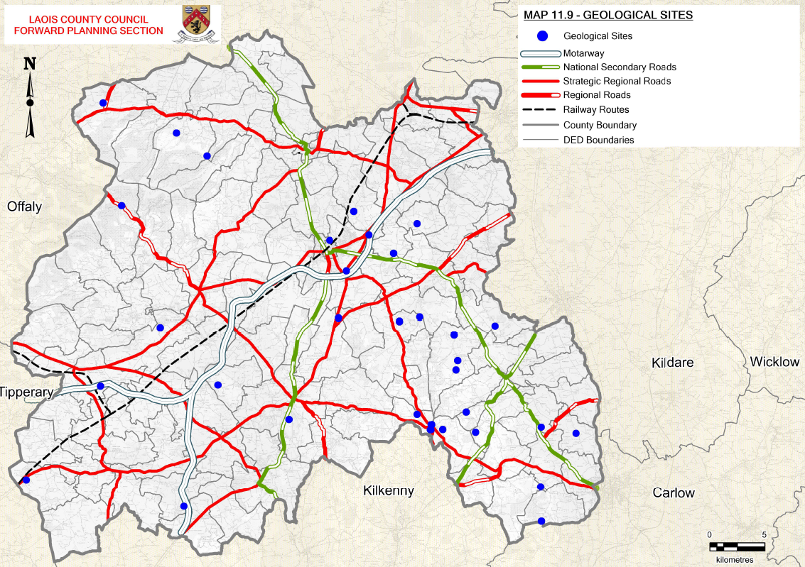
Table 11.8: County Geological Sites
|
SITE NAME |
PRINCIPAL CHARACTERISTICS |
TOWNLAND(S)/DISTRICT |
SUMMARY DESCRIPTION |
|
Abbeyleix Bog |
Peatland |
Tullyroe, Abbeyleix Demesne, Killamuck |
Abbeyleix Bog comprises an extensive area of peatland extending in a low-lying hollow |
|
Arless Quarry |
Quarry |
Rathtillig / Arless, south of Athy |
Small disused quarry. Shows basal Namurian contact |
|
Ballyadams Quarry |
Quarry |
Ballyadams formation |
Quarry |
|
Baunreagh Quarry |
Quarry |
Baunreagh |
Small roadside quarry in two sections |
|
Carrolls Quarry |
Ballysteen Limestone Formation |
Knockacoller / Castletown |
Typical representative of Ballysteen Limestone Formation. Quarry contains some cherty limestone and dolomite. |
|
Castlecomer Artesian Borehole |
Artesian Well |
Moyadd / Swan |
Artesian well |
|
Clogh River |
braided river channel |
Swan |
Series of dry braided river channels are found along the tightly meandering Clogh River. Braided or transitional to braided river may be influenced by input of sediment from mining waste |
|
Clonaslee Eskers |
Esker ridges |
Garryhedder, Coolagh, Castlecuffe, Larragan, Ballykineen Lower |
A complex series of ridges that bends around Slieve Bloom to become the Ridge of Portlaoise. Should be considered on its' own, however, as it has its own orientation and topography which is distinct from the Portlaoise Ridge. (Part of the Kinnity-Clonaslee Esker extending from Co. Laois to Co. Offaly) |
|
Clopook Cave |
Cave |
Clopook |
small cave is situated in the side of a possible relict karst tower |
|
Darkin Well |
Spring |
Straboe |
spring rising within a fenced compound. |
|
Farnans Quarry |
Quarry |
Farnans |
Working sandstone quarry |
|
Flemings Fireclay Quarries |
Fireclays |
Slatt Upper, Slatt Lower / Swan |
Double fireclays. The term fireclay was introduced by Richard Griffith |
|
Glebe Quarry |
Quarry |
Glebe |
Quarry exposes Devonian rocks of the Clonaslee Member, comprising the upper part of the Cadamstown Formation |
|
Glenbarrow |
Fluvial and Lacustrine Geomorphology |
Glenbarrow |
long section in the bed and banks of the river in Glenbarrow |
|
Hollymount |
Important Neogene site and Miocene - Late Pliocene |
Hollymount / Carlow |
This is an important Neogene (Miocene - Late Pliocene) site. dark non-marine clays & sands >50m with Miocene - Late Pliocene flora. Only proven Miocene in ROI |
|
Killeany Quarry |
Quarry |
Killeany |
small quarry cut into a small, but prominent, steep-sided limestone hill. |
|
Killeshin Glen |
Fossiliferous Rocks, Goniatites and Killeshin Siltstone Formation |
Coorlaghan, Keeloge / Killeshin |
A valuable stream section through Upper Namurian fossiliferous rocks in which goniatites are frequent. The Killeshin Siltstone Formation is mainly grey argillaceous or silty mudstones (Higgs 1987) poorly bedded with occasional plant remains, dark grey to black shales occur occasionally containing goniatites and lamellibranchs |
|
Kyle Spring |
Wells |
Kyle/Timahoe |
springs |
|
Lisduff Quarry |
Limestone Quarry |
Lisduff/Knockahaw |
Lisduff Oolite Member (Ballysteen Formation) bedrock comprising thick bedded, pale bluegrey, cross-bedded, well-jointed oolite of Lower Carboniferous (Mississippian) age |
|
Luggacurran Fireclay Pit |
Farm Borrow-pit |
Luggacurren |
site exposes Namurian rocks of part of the Killeshin Siltstone Formation |
|
Luggacurran Stream Section |
Namurian stratigraphical section through Castlecomer Plateau |
Luggacurren |
Two stream sections provide almost continuous exposure in the Namurian of the Castlecomer Plateau |
|
M7 Road Cut Derryvorrigan |
500m long road cut through limestone bedrock on the M7 Motorway |
Derryvorrigan |
Bedrock is Lower Carboniferous (Mississippian) dark-coloured muddy limestone (Ballysteen Formation) |
|
M8 Road Cut Addergoole |
800m long road cut through limestone bedrock on the M8 Motorway |
Addergoole |
Bedrock is Lower Carboniferous (Mississippian) shaly limestone (Durrow Formation) |
|
Modubeagh Mine Spring |
coal mine discharge spring with steps |
Swan |
An old coal mine northeast of Wolfhill Colliery. Reportedly has a capped well which was piped to Athy as a water supply. Reportedly has steps built to precipitate iron from mine adit spring |
|
Moyadd Stream |
Westphalian stratigraphical section |
Moyadd / Swan |
An excellent example of the typical lithologies of the basal Coal Measures is shown in this stream section. Many of the beds are fossiliferous. |
|
Old Rossmore |
Anthracite |
Rossmore, Clogrenan |
Anthracite |
|
Poulastore |
cave situated in the top of Killone Hill |
Killone, Killmurry, Ballythomas |
The cave is in Carboniferous Limestone rock, in the Clogrenan Formation which is the youngest part of the limestone sequence. The age of the cave is unknown but may be older than the immediate post glacial period of the last 10,000 years (Holocene) |
|
Rathleague Spring |
warm spring |
Rathleague Derry |
warm spring |
|
Ridge of Portlaoise |
Esker ridges |
Townparks, Ballycullenbeg, Strahard, Debicot, Acragar, Cloncosney, Derrydavy, Kyletalesha, Ballytegan, Gorteen, Maryborough, Borris, Beladd, Downs, Rathleague, Meelick, Capoley, Ballycarnan |
A glacial esker ridge. It has a road on top. This long, narrow ridge is an excellent example of a straight, uncomplicated esker which does not have a complex topography. It lies 90 degrees to the Kinnity-Clonaslee esker, but was formed in the same tunnel system. |
|
Rock of Cashel |
deposition features, crinoids and brachiopods |
Cashel |
Small outcrop of limestone with characteristics of deposition in turbid environments. The rock is highly fossiliferous with crinoids and brachiopods |
|
Rock of Dunamase |
Small Limestone hills: Hums. |
Park or Dunamase |
One of a series of small limestone hills, erosion features known as 'hums' above a plain. Youngest Brigantian strata in the area. Rock of Dunamase - representative site for Stradbally Hills. Site is large enough to include the glacial sediments around it. |
|
Sluggory Cross Roads |
complex active sinkhole (swallow hole) in karstic limestone, northeast of Portlaoise |
Ballydavis, Rathbrennan |
The sinkhole, drainage and cave development are probably all post-glacial in age, formed over the last 11,000 years |
|
Timahoe Eskers |
Esker ridges |
Esker, Coolnabracca, Kyle, Orchard Lower, Clondoolagh, Fallowbeg Lower, Guileen, Clopook, Fallowbeg Middle |
One of the best examples of esker ridges in the country showing branching and other characteristic features. A nice anatomising ridge, associated with moraine and fan features in a nice topographic setting. |
11.11.1 ESKER
The Council recognises the unique importance of esker landscape and its archaeological and historic value. All proposals for sand and gravel extraction will be determined by considering the need to conserve the environment and the extent to which proposed developments would be damaging. There is a presumption against new quarry development on eskers. The Council recognises that the exploitation of deposits can have seriously damaging environmental impact on the esker network.
|
Policy Objectives for Eskers |
|
|
GEO 5 |
Protect, preserve and conserve the landscape and natural heritage and geo-diversity values of esker systems from inappropriate development. Ensure that any plan or project affecting eskers are adequately assessed with regard to their potential impact on the environment |
|
GEO 6 |
Assess applications for quarrying activity and gravel extraction and other development in proximity to eskers, with respect to their landscape importance or amenity value and the need to conserve them free from inappropriate development and to conserve their environmental character values and the extent to which proposals would damage these qualities. |
[1] Except as provided for in Article 6(4) of the Habitats Directive, viz. There must be: a) no alternative solution available, b) imperative reasons of overriding public interest for the project to proceed; and c) Adequate compensatory measures in place.
[1] European Union (2013): Building a Green Infrastructure for Europe
Contents
Materials
Comments
Comments
Nore Vision Submission
Background, Work to date and Objects of The Nore Vision
The Nore Vision started as a consultation process funded by Leader Partnerships in Kilkenny, Laois and South & North Tipperary....
Peatland Rehabilitation
Chapter 11 Biodiversity and Natural Heritage
We note the references throughout this section of the Draft Plan in particular the policies and objectives with respect to Biodiversity,...
Submission on Biodiversity and Natural Heritage
The Assembly welcome the inclusion of Chapter 11 relating to Biodiversity and Natural Heritage of County Laois. It is considered that the array of topics covered as part of this Draft Plan chapter is...
Suggested policy and guideline measures regarding Swifts
On behalf of BirdWatch Ireland.
Following last nights consultation meeting and after further discussion with Catherine Casey on the topic I would like to put forward the following suggested...